What is a topographic map? Topographic map definition
Topographic maps produced by Natural Resources, offer detailed information on a particular area and are used for several types of activities such as emergency preparedness, urban planning, resource development, and surveying to camping, canoeing, adventure racing, hunting, and fishing.
This guide will help the user understand the basics of topographic maps. The guide provides an overview of mapping concepts, along with tips on how to use a topographic map, explanations of technical terminology and examples of symbols used to represent topographic features on topographic maps.
Why? Topographic maps represent the Earth’s features accurately and to scale on a twodimensional surface. Topographic maps are an excellent planning tool and guide and, at the same time, help make outdoor adventures enjoyable and safe.
Topographic map definition
What is a topographic map? topographic map definition
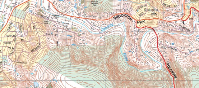
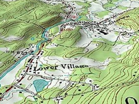
A topographic map is a detailed and accurate illustration of man-made and natural features on the ground such as roads, railways, power transmission lines, contours, elevations, rivers, lakes and geographical names.
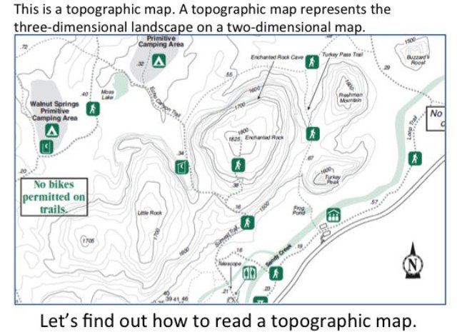
The topographic map is a two-dimensional representation of the Earth’s three-dimensional landscape. The most frequently used Canadian topographic map is at a scale of 1:50 000.
What is a topographic map?
Topographic map definition: What information is on a topographic map?
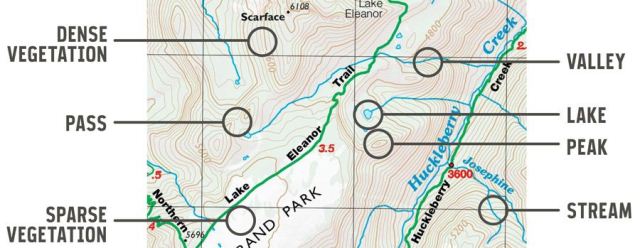
Topographic maps identify numerous ground features, which can be grouped into the following categories:
- Relief: mountains, valleys, slopes, depressions as defined by contours
- Hydrography: lakes, rivers, streams, swamps, rapids, falls
- Vegetation: wooded areas
- Transportation: roads, trails, railways, bridges, airports/airfield, seaplane anchorages
- Culture: buildings, urban development, power transmission line, pipelines, towers
- Boundaries: international, provincial/territorial, administrative, recreational, geographical
- Toponymy: place names, water feature names, landform names, boundary names
Refer to the map legend for a complete listing of all features and their corresponding symbols. Information along the map borders provides valuable details to help you understand and use a topographic map. For example, here you will find the map scale and other important information about the map such as the year, the edition and information pertaining to the map data.
Topographic map example
Topographic map definition: Is a topographic map similar to a road map?
Both types of maps show roads, water features, cities, and parks, but that’s where the similarity ends.
- Topographic maps show contours, elevation, forest cover, marsh, pipelines, power transmission lines, buildings and various types of boundary lines such as international, provincial and administrative, and many others.
- Topographic maps show a universal transverse Mercator (UTM) grid, allowing the user to determine precise positions. In basic terms, topographic maps allow the user to see a threedimensional landscape on a two-dimensional surface.
Topographic map definition: What do the colors mean?
A variety of colors can be found on a map, each relating to different types of features.
- Black shows cultural features such as buildings, railways, and power transmission lines. It is also used to show geographical names (toponymy), certain symbols, geographic coordinates, and precise elevations.
- Blue represents water features, such as lakes, rivers, falls, rapids, swamps, and marshes. The names of water bodies and watercourses are also shown in blue, as are magnetic declination and UTM grid information.
- Green indicates vegetation such as wooded areas, orchards, and vineyards.
- Some areas are mapped in black and white (monochrome).
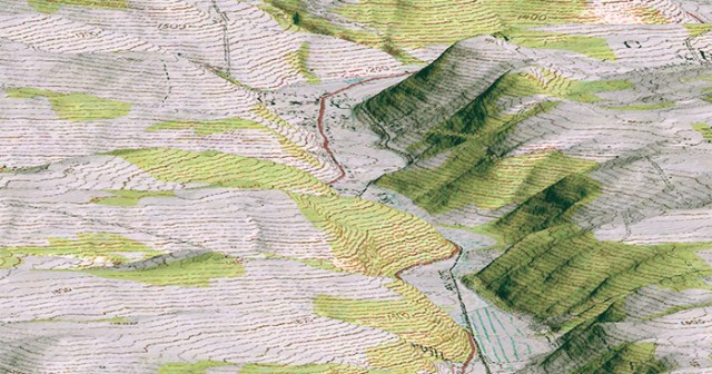
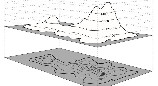
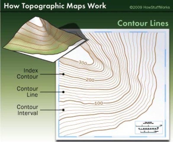
Topographic contour lines
Topographic map definition: What are contour lines?
Contour lines connect a series of points of equal elevation and are used to illustrate relief on a map. They show the height of ground above mean sea level (MSL) either in meters or feet and can be drawn at any desired interval. For example, numerous contour lines that are close to one another indicate hilly or mountainous terrain; when further apart they indicate a gentler slope; and when far apart they indicate flat terrain.
Topographic map scale
What is scale? Topographic map definition.
Maps are made to scale. In each case, the scale represents the ratio of a distance on the map to the actual distance on the ground. A standard topographic map is produced at 1:50000, where 2 cm on the map represents 1 km on the ground.
Medium-scale maps (e.g. 1:50 000) cover smaller areas in greater detail, whereas small-scale maps (e.g. 1:250 000) cover large areas in less detail.
A 1:250 000 scale national topographic system (NTS) map covers the same area as sixteen 1:50 000 scale NTS maps.
Measure distance on map
Topographic map definition: How do I measure distance on a map?
Use the scale bar found at the bottom of every NRCan topographic map to determine distances between points or along lines on the map sheet. Use the secondary division on the left of the scale bar for measuring fractions of a kilometer.
Topographic map definition: What is a grid?
A grid is a regular pattern of parallel lines intersecting at right angles and forming squares; it is used to identify precise positions. To help you locate your position accurately on the surface of the Earth (or map sheet), topographic maps have two kinds of referencing systems:
- universal transverse Mercator (UTM) projection (easting/northing)
- geographic: degrees and minutes (longitude/latitude)
The projection used for topographic maps is UTM.
The UTM grid is a square grid system of lines depicted on maps and based on the transverse Mercator projection. It can be used to accurately locate the position of features on the map by distance or direction. To express your location in grid coordinates or geographic coordinates, read the following section.
what features are shown on a topographic map?
Topographic map latitude longitude: How can I find or express a location on a map?
You can find or express a location on a map by using geographic coordinates (longitude, latitude) or by using UTM grid coordinates (easting, northing).
Geographic coordinates are expressed in degrees, minutes and seconds and can be determined on the map by using the longitude and latitude graticules placed along the edges of the map.
Latitude graticules are placed along the east and west edges of the map and longitude graticules are placed along the north and south edges of the map. The longitude and latitude of your location can be determined by projecting your location to the map edges and then by reading the corresponding latitude and longitude values.
UTM grid coordinates are expressed in meters and can be determined on the map by using the UTM grid lines. These grid lines are equally spaced horizontal and vertical lines superimposed over the entire map.
The coordinate value for each grid line can be found along the edge of the map. Northing values can be read along the east or west edges of the map and easting values can be read along the north or south edges of the map. The easting and northing of your location can be determined by projecting your location to the nearest horizontal and vertical grid lines and then reading the corresponding easting and northing values.
GPS latitude and longitude
How can I determine where I am on a map using a GPS receiver?
If you have a GPS receiver, your location can be determined very quickly. This satellite receiving system displays a position in terms of latitude, longitude, and height, providing you with precise coordinates for map reference. (Some receivers also provide direct conversion of position to a selected map grid such as UTM.)
With this GPS coordinate, you can then use the geographic or UTM grid reference system on the map to determine where you are
How can I determine where I am on a map without using a GPS?
If you do not have a GPS receiver, identify as many features around you as you can, man-made or natural, and locate those same features on your map. Then orient the map, in relation to yourself, so that its orientation corresponds to the ground features that you have identified. If this is difficult to do, use a compass to help you orient the map to north and try again to identify surrounding features.
By estimation, or by using a compass, take bearings to the known features and then from the known features, plot the bearing lines. The intersection of these lines should indicate your location.

How to navigate with a compass and a topographic map?
Navigating by compass requires determining bearings with respect to true or grid north from a map sheet and converting them to magnetic bearings for use with a compass.
One way of doing this is described in the following steps:
- Place the compass on the map with the direction-of-travel arrow pointing along the desired line of travel.
- Rotate the compass dial so that the parallel lines within the capsule line up with the grid lines on the map. Convert the grid bearing to a magnetic bearing by using the information given (as in the accompanying diagram) on the map sheet. If the declination is west, add it to the grid bearing; if declination is east, subtract it from the grid bearing
- Adjust the dial to read the value of the magnetic bearing opposite the direction-of-travel arrow. Make certain to account for the difference between grid north and true north.
- Now pick up and rotate the whole compass until the red end of the needle points to the north marker on the dial. The direction-of-travel arrow on the compass card will point to your destination. Choose a landmark in that direction and walk toward it.
Topographic map definition
A topographic map is a detailed and accurate illustration of man-made and natural features on the ground such as roads, railways, power transmission lines, contours, elevations, rivers, lakes and geographical names.
Topographic maps identify numerous ground features, which can be grouped into the following categories:
-Relief: mountains, valleys, slopes, depressions as defined by contours
-Hydrography: lakes, rivers, streams, swamps, rapids, falls
-Vegetation: wooded areas
-Transportation: roads, trails, railways, bridges, airports/airfield, seaplane anchorages
Both types of maps show roads, water features, cities, and parks, but that’s where the similarity ends.
-Topographic maps show contours, elevation, forest cover, marsh, pipelines, power transmission lines, buildings and various types of boundary lines such as international, provincial and administrative, and many others.
-Topographic maps show a universal transverse Mercator (UTM) grid, allowing the user to determine precise positions. In basic terms, topographic maps allow the user to see a threedimensional landscape on a two-dimensional surface.
If you have a GPS receiver, your location can be determined very quickly. This satellite receiving system displays a position in terms of latitude, longitude, and height, providing you with precise coordinates for map reference.
A topographic map is a detailed and accurate two-dimensional representation of natural and human-made features on the Earth’s surface. These maps are used for a number of applications, from camping, hunting, fishing, and hiking to urban planning, resource management, and surveying.
Like General Reference Maps, Topographic Maps are a summary of the landscape and show important physical (natural and man-made) features in an area. The primary difference is that they show an elevation in detail. Characteristics of topographic maps include: they show elevation using contour lines.
In cartography and geology, a topological map is a type of diagram that has been simplified so that only vital information remains and unnecessary detail has been removed. These maps lack scale, and distance and direction are subject to change and variation, but the relationship between points is maintained.
Topographic maps are maps at large and medium scales that incorporate a huge variety of information. The basic coverage is based on measurements made in the field and/or from aerial photographs. Derived topographical maps are prepared by reduction and generalization from the original basic maps.
All components of a topographic map at a specified scale are of equal importance: water, terrain, communication, built-up areas, vegetation, etc., as well as the lettering of place-names and geographical and cultural features.
Types of Topographical Survey
While most people think of land surveys in the most basic sense—that is, the drawing of the boundaries of property—there are actually many different ways of surveying that service many different industries.
Topographic Survey
Surveying has to do with the determination of the relative spatial location of points on or near the surface of the earth.