
Topography is the study of the shape and features of land surfaces. The topography of an area could refer to the surface shapes and features themselves, or a description (especially their depiction in maps).
What Is Topography?
Topography is a broad term used to describe the detailed study of the earth’s surface. This includes changes in the surface such as mountains and valleys as well as features such as rivers and roads.
It can also include the surface of other planets, the moon, asteroids, and meteors. The topography is closely linked to the practice of surveying, which is the practice of determining and recording the position of points in relation to one another.
Topography examples
Modern-day topography is generally concerned with the measurement and recording of elevation contours, producing a three-dimensional representation of the earth’s surface.
A series of points are chosen and measured in terms of their horizontal coordinates, such as latitude and longitude, and their vertical position, in terms of altitude. When recorded in a series, these points produce contour lines that show gradual changes in the terrain.
Types of topography
The most read
Topographic Survey
Surveying has to do with the determination of the relative spatial location of points on or near the surface of the earth.
Bathymetric Survey
The variation in relief constitutes the morphology of the ocean floor. Charting the ocean is very important for many reasons.
Underwater Topography Maps
Detailed depth contours provide the size, shape, and distribution of underwater features. The map serves as a tool for performing scientific, engineering, marine geophysical, and environmental studies.
Types of Topographical Survey
While most people think of land surveys in the most basic sense, that is, the drawing of the boundaries of a property, there are actually many different ways of surveying that service many different industries.
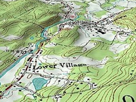
Topographic Map definition
Topographic maps offer detailed information on a particular area and are used for several types of activities.
Types of contour lines
A topographic map is printed on a flat piece of paper yet it provides a picture of the terrain and manmade features through the use of contour lines, colors, and symbols.
Topographic Survey Cost
As a home or property owner, you may need to inspect your land. What is the cost of the topographic survey?
Hydro Turbine generator
Surge tanks can provide a fundamental feature for the hydraulic design of hydropower projects.
Surge Tank in Hydroelectric Power Plant
A surge tank is a water storage device that is used in a hydroelectric power plant, to cushion the variation of excess pressure.
What are examples of topography?
Examples include mountains, hills, valleys, lakes, oceans, rivers, cities, dams, and roads. Elevation – The elevation, or height, of mountains and other objects, is recorded as part of the topography. It is usually recorded in reference to sea level (the surface of the ocean).
The topography is a detailed map of the surface features of the land. It includes the mountains, hills, creeks, and other bumps and lumps on a particular hunk of earth. This handy word is a Greek-rooted combo of topos meaning “place” and graphein “to write.” It’s the geographical contours of the land.
An objective of topography is to determine the position of any feature or more generally any point in terms of both a horizontal coordinate system such as latitude, longitude, and altitude. Identifying (naming) features, and recognizing typical landform patterns are also part of the field.