
Topographic survey: Surveying has to do with the determination of the relative spatial location of points on or near the surface of the earth.
- It is the art of measuring horizontal and vertical distances between objects, measuring angles between lines, determining the direction of lines, and of establishing points by predetermined angular and linear measurements.
- Along with the actual survey, measurements are the mathematical calculations.
- Distances, angles, directions, locations, elevations, areas, and volumes are thus determined from the data of the survey.
- Survey data is portrayed graphically by the construction of maps, profiles, cross-sections, and diagrams
Fundamentals of land surveying
The importance of the Surveying
Land surveying is basically an art and science of mapping and measuring land. The entire scope of the profession is wide; it actually boils down to calculate where the land boundaries are situated. This is very important as, without this service, there would not have been railroads, skyscrapers could not have been erected and neither any individual could have put fences around their yards for not intruding others land.

Types of a survey in civil
Types of surveying
- Geodetic Surveying:
- The type of surveying that takes into account the true shape of the earth. These surveys are of high precision and extend over large areas.
- Plane Surveying:
- The type of surveying in which the mean surface of the earth is considered as a plane, or in which its spheroidal shape is neglected, with regard to horizontal distances and directions.
Different survey methods
Different methods of Surveying:
- Control Survey: Made to establish the horizontal and vertical positions of arbitrary points.
- Boundary Survey: Made to determine the length and direction of landlines and to establish the position of these lines on the ground.
- Topographic Survey: Made to gather data to produce a topographic map showing the configuration of the terrain and the location of natural and man-made objects.
- Hydrographic Survey: The survey of bodies of water made for the purpose of navigation, water supply, or sub-aqueous construction.
- Mining Survey: Made to control, locate and map underground and surface works related to mining operations.
- Construction Survey: Made to lay out, locate and monitor public and private engineering works.
- Route Survey: Refers to those control, topographic, and construction surveys necessary for the location and construction of highways, railroads, canals, transmission lines, and pipelines.
- Photogrammetric Survey: Made to utilize the principles of aerial photogrammetry, in which measurements made on photographs are used to determine the positions of photographed objects.
- Astronomical survey: generally involve imaging or “mapping” of regions of the sky using telescopes. (Topographic survey cost)

Chain surveying
Topographic survey cost: Distance Measuring (Chaining surveying)
English mathematician Edmund Gunter (1581-1626) gave to the world not only the words cosine and cotangent, and the discovery of magnetic variation, but the measuring device called Gunter’s chain shown below. Edmund also gave us the acre which is 10 square chains. The Gunter’s chain is 1/80th of a mile or 66 feet long. It is composed of 100 links, with a link being 0.66 feet or 7.92 inches long. Each link is a steel rod bent into a tight loop on each end and connected to the next link with a small steel ring.
Starting in the early 1900’s surveyors started using steel tapes to measure distances. These devices are still called “chains” to this day.
Chain surveying procedure
Procedure of Chaining
- It must be remembered in surveying, that under most circumstances, all distances are presumed to be horizontal distances and not surface distances.
- This dictates that every field measurement is taken be either measured horizontally or, if not, reduced to a horizontal distance mathematically.
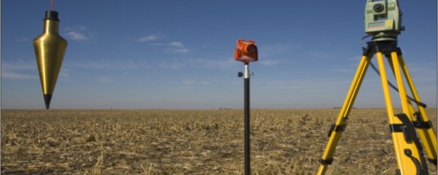
- In many instances, it is easiest to simply measure the horizontal distance by keeping both ends of the chain at the same elevation. This is not difficult if there are less than five feet or so of elevation change between points. A hand level or “pea gun” is very helpful for maintaining the horizontal position of the chain when “level chaining.” A pointed weight on the end of a string called a “plumb bob” is used to carry the location of the point on the ground up to the elevated chain by simply suspending the plumb bob from the chain such that the point of the plumb bob hangs directly above the point on the ground.
- When the difference in elevation along the measurement becomes too great for level chaining, other methods are called for. One option, “break chaining”, involves simply breaking the measurement into two or more measurements that can be chained level. (Topographic survey cost)
Electronic distance meter
Distance Measuring (Electronic Distance Meters)
In the early 1950s, the first Electronic Distance Measuring (EDM) equipment was developed. These primarily consisted of electro-optical (light waves) and electromagnetic (microwave) instruments. They were bulky, heavy and expensive. The typical EDM today uses the electro-optical principle. They are small, reasonably lightweight, highly accurate, but still expensive.
Purpose of chain surveying
Principle of Chaining
- To measure any distance, you simply compare it to a known or calibrated distance; for example by using a scale or tape to measure the length of an object. In EDM’s the same comparison principle is used. The calibrated distance, in this case, is the wavelength of the modulation on a carrier wave.
- Modern EDM’s use the precision of a Quartz Crystal Oscillator and the measurement of phase-shift to determine the distance.
- The EDM is set up at one end of the distance to be measured and a reflector at the other end.
- The EDM generates an infrared continuous-wave carrier beam, which is modulated by an electronic shutter (Quartz crystal oscillator).
- This beam is then transmitted through the aiming optics to the reflector.
- The reflector returns the beam to the receiving optics, where the incoming light is converted to an electrical signal, allowing a phase comparison between transmitted and received signals.
- The amount by which the transmitted and received wavelengths are out of phase can be measured electronically and registered on a meter to within a millimeter or two.
Topographic survey cost
Measuring angles
Angle Measuring: Topographic survey cost
Measuring distances alone in surveying does not establish the location of an object. We need to locate the object in 3 dimensions. To accomplish that we need:
- Horizontal length (distance)
- The difference in height (elevation)
- Angular direction.
An angle is defined as the difference in direction between two convergent lines. A horizontal angle is formed by the directions to two objects in a horizontal plane. A vertical angle is formed by two intersecting lines in a vertical plane, one of these lines horizontal. A zenith angle is the complementary angle to the vertical angle and is formed by two intersecting lines in a vertical plane, one of these lines directed toward the zenith.
Different types of angles
Types of Measured Angles
- Interior angles are measured clockwise or counter-clockwise between two adjacent lines on the inside of a closed polygon figure.
- Exterior angles are measured clockwise or counter-clockwise between two adjacent lines on the outside of a closed polygon figure.
- Deflection angles, right or left, are measured from an extension of the preceding course and the ahead line. It must be noted when the deflection is right (R) or left (L).
Theodolite
A Theodolite is a precision surveying instrument; consisting of an alidade with a telescope and an accurately graduated circle, and equipped with the necessary levels and optical-reading circles. The glass horizontal and vertical circles, optical-reading system, and all mechanical parts are enclosed in an alidade section along with 3 leveling screws contained in a detachable base or tribrach.
Transits
A Transit is a surveying instrument having a horizontal circle divided into degrees, minutes, and seconds. It has a vertical circle or arc. Transits are used to measure horizontal and vertical angles. The graduated circles (plates) are on the outside of the instrument and angles have to be read by using a vernier.
Closed traverse procedure
Procedure for running a traverse: Topographic survey cost
To begin any traverse, a known point must be occupied. (To occupy a point means to set up and level the transit or theodolite, directly over a monument on the ground representing that point.) Next, a direction must be established. This can be done by sighting with the instrument a second known point, or any definite object, which is in a known direction from the occupied point.
The object that the instrument is pointed to in order to establish a direction is known as a backsight. Possible examples would be another monument on the ground, a radio tower or water tank on a distant hill, or anything with a known direction from the occupied point. A celestial body such as Polaris or the sun could also be used to establish an initial direction.
Once the instrument is occupying a known point, for example, point number 2, and the telescope has been pointed toward the backlight, perhaps toward point number 1, then an angle and a distance is measured to the first unknown point. An unknown point being measured is called foresight. With this data, the position of this point (let’s call it point number 100) can be determined.
The next step is to move the instrument ahead to the former foresight and duplicate the entire process.
GPS global positioning system
How satellite distance is measured
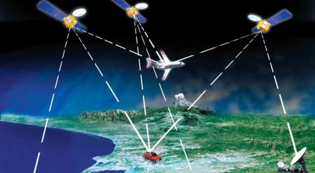
The Global Positioning System (GPS) is a navigational or positioning system developed by the United States Department of Defense. It was designed as a fast positioning system for 24 hours a day, three-dimensional coverage worldwide.
It is based on a constellation of 21 active and 3 spare satellites orbiting 10,900 miles above the earth. The GPS (NAVSTAR) satellites have an orbital period of 12 hours and are not in geosynchronous orbit (they are not stationary over a point on the earth). They maintain a very precise orbit and their position is known at any given moment in time.
This constellation could allow GPS user access to up to a maximum of 8 satellites anywhere in the world.
GPS provides Point Position (Latitude/Longitude) and Relative Position (Vector). GPS can differentiate between every square meter on the earth’s surface thus allowing a new international standard for defining locations and directions.
GPS satellite system
The Principles of GPS
For centuries man has used the stars to determine his position. The extreme distance from the stars made them look the same from different locations and even with the most sophisticated instruments could not produce a position closer than a mile or two. The GPS system is a constellation of Manmade Stars at an orbit high enough to allow a field of view of several satellites, yet low enough to detect a change in the geometry even if you moved a few feet.
A typical conventional survey establishes positions of unknown points by occupying a known point and measuring the unknown points. GPS is somewhat the opposite.

GPS stands for a global positioning system
How satellite distance is measured
Each GPS satellite continually broadcasts a radio signal. Radio waves travel at the speed of light (186,000 miles per second) and if we measure how long it took for the signal to reach us we could compute the distance by multiplying the time in seconds by 186,000 miles per second.
In order to measure the travel time of the radio signal, the satellite broadcasts a very complicated digital code. The receiver on the ground generates the same code at the exact time and when the signal is received from the satellite, the receiver compares the two and measures the phase shift to determine the time difference.
Differential GPS
To achieve sub-centimeter accuracies in positions, we need a survey-grade receiver and a technique called Differential GPS. By placing a receiver at a known location, a total error factor that accounts for all the possible errors in the system can be computed which can be applied to the position data of the other receivers in the same locale. The satellites are so high-up that any errors measured by one receiver could be considered to be exactly the same for all others in the immediate area.
Boundary and topographic survey cost
Differential leveling
Differential leveling is the process used to determine a difference in elevation between two points. A Level is an instrument with a telescope that can be leveled with a spirit bubble. The optical line of sight forms a horizontal plane, which is at the same elevation as the telescope crosshair.
By reading a graduated rod held vertically on a point of known elevation (Bench Mark) a difference in elevation can be measured and a height of instrument (H.I.) calculated by adding the rod reading to the elevation of the benchmark. Once the height of the instrument is established, rod readings can be taken on subsequent points and their elevations calculated by simply subtracting the readings from the height of the instrument.
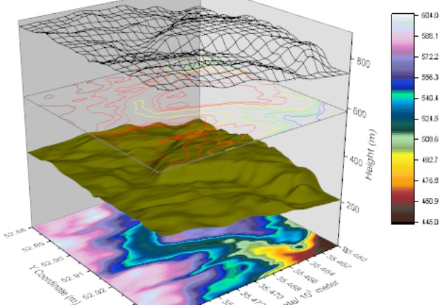
Digital terrain model
A digital Terrain Model (DTM) is a numerical representation of the configuration of the terrain consisting of a very dense network of points of known X, Y, Z coordinates. Modern surveying and photogrammetric equipment enable rapid three-dimensional data acquisition. A computer processes the data into a form from which it can interpolate a three-dimensional position anywhere within the model.
Think of a DTM as an electronic lump of clay shaped into a model representing the terrain. If alignment was draped on the model and a vertical cut made along the line, a side view of the cut line would yield the alignment’s original ground profile. If vertical cuts were made at right angles to the alignment at certain prescribed intervals, the side views of the cuts would represent cross-sections. If horizontal cuts were made at certain elevation intervals, the cut lines when viewed from above would represent contours.
A DTM forms the basis for modern highway location and design. It is used extensively to extract profiles and cross-sections, analyze alternate design alignments, compute earthwork, etc.
Topographic cross-section
Cross-sections are lines 90 degrees perpendicular to the alignment (P-Line, L-Line, the centerline of stream, etc.), along which the configuration of the ground is determined by obtaining elevations of points at known distances from the alignment.
Cross-sections are used to determine the shape of the ground surface through the alignment corridor. The shape of the ground surface helps the designer pick his horizontal and vertical profile. Once the alignment is picked, earthwork quantities can be calculated. The earthwork quantities will then be used to help evaluate the alignment choice.
In addition to earthwork calculations, cross-sections are used in the design of storm sewers, culvert extensions and the size and location of new culverts.
Topographic survey cost
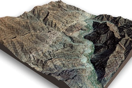
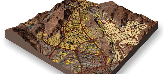
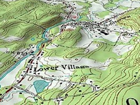
The topography is a detailed map of the surface features of the land. It includes the mountains, hills, creeks, and other bumps and lumps on a particular hunk of earth. Topography represents a particular area in detail, including everything natural and man-made — hills, valleys, roads, or lakes.
A topographic profile is a cross-sectional view along a line drawn through a portion of a topographic map.
Leveling is a process of determining the height of one level relative to another. It is used in surveying to establish the elevation of a point relative to a datum or to establish a point at a given elevation relative to a datum
To determine the relative position of any objects or points of the earth. To determine the distance and angle between different objects. To prepare a map or plan to represent an area on a horizontal plane. To develop methods through the knowledge of modern science and technology and use them in the field.
Types of Topographical Survey
While most people think of land surveys in the most basic sense—that is, the drawing of the boundaries of property—there are actually many different ways of surveying that service many different industries.
Topographic Map definition
Topographic maps offer detailed information on a particular area and are used for several types of activities such as emergency preparedness, urban planning, resource development, and surveying to camping, canoeing, adventure racing, hunting, and fishing.