
Bathymetric Survey equipment: Bathymetry is the study of the underwater depth of the lake and ocean floors. In the bathymetric survey, charts are produced to support the safety of surface or sub-surface navigations which usually show seafloor relief or terrain as contour lines (depth contours), and such a chart provides surface navigational information. The survey sets for best description of the submarine topographical
features that may include sound velocity and slope corrections that are more accurate but eliminate the safety bias.
Bathymetric and hydrographic survey
Bathymetric survey equipment are important for many purposes; such include sedimentation purposes to check for accretion or erosion, pre and post dredging bathymetry, that is to determine the existing status of the water body or to ascertain the dredged volume. It can also be done prior to pipeline and cable (laying) positioning, fishing, and other geophysical exploration exercises.
Updating of bathymetric chart is a daunting task and cannot be overpassed due to its importance in estimating or determining temporal changes in an ocean floor which in effect; provides accurate information for public usage, in terms of planning, engineering design, construction, operation, maintenance, and regulation of navigation, flood control, river engineering, charting, and coastal engineering projects.
Resurvey policy especially that of bathymetry gives bounds for the reliability of identified sea erosion and accretion areas, determination of sediment transport pathways, the magnitude of sediment transport estimates, and the validity of sediment budget estimates.
Bathymetric survey cost
Comparison of digital bathymetric data for the same region but different time periods provides a method for estimating or calculating the net movement of sediment into (accretion) and out of (erosion) a study area. Producing a bathymetric chart; tidal observation and reduction is a must to reduce the sounding depth to chart datum.
Tidal observation is conducted prior to and concurrently with sounding operations period and can be done on the established gauge or temporarily on any selected position where the water level hardly goes below the zero reading of the measuring device (Temporary gauge).
The reduction applicable to sounding depth is done based on the rise and fall differential subtraction for gauge data using an instantaneous timing interval for each sounding point. Further processes have to do with spike removal, HYPACK matrix generation and possibly preparation of schema for ideal data structuring; then the production of a bathymetric chart.
A proper environmental impact assessment needs to be done in order to assess the level of impact caused by man and nature, especially as it concerns coastal waters.
The bathymetric survey equipment is important for the production of the up-to-date bathymetric chart, due to mining exercises opined by local miners and licensed dredging companies.
In the absence of mining exercise, there is a need to investigate and account for sediment deposit or eroded, so that proper planning responses can be implemented. It is, therefore, necessary to update the bathymetric chart covering, which would be compared with the earlier bathymetric survey equipment; for investigating sediments (Accretion and Erosion) and dredged region area.
Marine protected areas
Bathymetry surveys are the first step for every conservation effort on Marine Protected Areas (MPAs). Maps depicting depth and bottom geomorphology are used to generate hillsides, that later become base maps for other themes, such as fish distribution, bottom types, and water quality.
Bathymetry map availability is limited or non-existent at the scales that are necessary for MPA management plans. Survey costs by traditional-sounding methods or new technologies, such as LIDAR, are prohibitive for most MPA budgets.
Remote Sensing bathymetry is yet unreliable, except for crystal clear waters. A low-cost technique, based on commercially available GPS-echosounder units was applied to obtain detailed bathymetry of two MPAs in coastal.
Hydrographic survey
Hydrographic Charts as used by seafarers are based on data accumulated over years of professional surveying operations. Standard hydrographic charts either in paper form or as ENC are available for most areas of the world and are quite inexpensive thanks to two factors: government-subsidized hydrographic surveys and a large number of charts printed for numerous users.
Dedicated charts, as produced for the offshore oil & gas industry, coastal engineering, cable-laying operations, etc. cost a similar amount to produce but are much more expensive to buy due to the limited number of users and additional requirements. For these charts, navigational (safe) depth is insufficient; detailed sea bottom morphology is required.
Hydrographic services
In both cases, the basis for the hydrographic charts, bathymetric survey equipment operations, have been and still are a rather costly affair. In the old days they were costly because the instruments used, lead line, sextant and the like, provided only a sounding every now and then whilst ship-time ticked by.
Nowadays bathymetric information is typically gathered from dedicated survey vessels using single or multi-beam echo sounding systems. The prime cost factor in ship-borne surveys is the time and thus the expense involved in conducting the survey and in data post-processing. Delays due to factors such as weather-related downtime, logistics, red tape and instrument breakdown can cause operational costs to go through the roof.
Bathymetric survey equipment cost
The execution of a cost-effective hydrographic survey necessitates the use of a package of three:
- Well trained personnel,
- Accurate, reliable instrumentation and
- A suitable survey vessel.
Bathymetric Survey Equipment: How can we save on these?
Survey personnel has, historically, not been in the top regions of offshore personnel salary scales. There are signs that this is changing gradually (which is necessary to keep enough people in our business!) and the only way to reduce costs here is to deploy personnel on the job.
Thanks to advanced survey systems and computer equipment, this is a possibility, to a certain degree. The other way would be to work longer hours to keep equipment and ship operational for longer periods, but this is done already: for most offshore survey operations, a 24hrs working day is no exception.
The other possibility to optimize survey operations is to deploy more advanced, more productive survey systems. Positioning-wise, we are “on dry ground” already: The horizontal positioning world has been turned upside down in the past 25 years by the implementation of GPS and DGPS.
DGPS survey
Although freely available DGPS has a stated horizontal accuracy of +/-10 meters (95 percent), many mariners are claiming 3-meter or better accuracy with this system. With selective availability set to zero, the most basic GPS receiver in a non-differential mode may offer 10-15 meter horizontal accuracy.
Some sophisticated survey receivers now advertise sub-meter accuracy and with (long-range) RTK systems, the cm accuracy levels can be reached for both horizontal accuracy and vertical referencing.
Echo sounder for bathymetric survey
Bathymetric Survey Equipment: What else can we ask for?
For bathymetric measurements, great improvements have been made the last two decennia. In the past, survey lines were sailed and only the depth directly under the vessel was measured using a single beam echo sounder.
Then, multi-transducer systems were developed whereby an array of transducers was fitted on a pole, fitted perpendicularly onto the vessel, giving a swath width of the length of the pole. The system is still very useful for very shallow water.
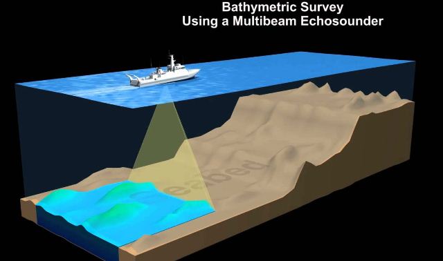
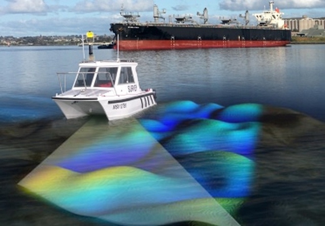
Nowadays, we have multi-beam, providing fan-shaped coverage of the seafloor similar to side-scan sonar, but the output data is in the form of depths rather than images.
Multibeam echo sounder
The multi-beam system measures and records the time for the acoustic signal to travel from the transducer to the seafloor and back. For bathymetric purposes, multi-beam transducers are generally attached to a vessel, rather than being towed like a side scan. Therefore, the coverage area on the seafloor is dependent on the depth of the water, typically two to four times the water depth.
The production rate of multi-beam is many times that of a single beam and for an increasing number of (larger) surveys, it became a price decreasing survey tool. Post-processing of the results of this system has still a considerable price impact due to the vast amount of data that is generated, but new processing packages, such as Triton Images’ multi-beam software, are quickly helping to overcome this.
Survey platform
The third, but a major factor of costs is the survey platform. Indeed, it may be well possible to select suitable personnel and equipment for a reasonable price, but the platform on which these have to be placed to perform the work, a ship, is still the major cost-component of bathymetric survey equipment.
Improved ship design, less ship’s crew, higher survey speed, less fuel consumption and on-board data processing and charting may increase the vessel’s cost-effectiveness, but ships remain expensive.
Bathymetric LIDAR system
For certain applications such as surveys in relatively shallow, clean water, Lidar solutions with combined RTK-DGPS / Inertial systems will provide alternatives.
The high speed and enormous amount of data generated enable covering large areas in short survey time. Lightweight Lidar systems (Hawkeye 2) are being developed and smaller airplanes or helicopters can be deployed from remote airfields all over the world to execute such surveys.
For large projects, whereby a multitude of sensors have to be deployed over prolonged periods of time, Zeppelin-type aircraft may become a cost-saving platform: with payloads of over 35 tonnes, the endurance of several weeks in the air and an airspeed of 150 knots, large areas can be surveyed at reasonably low cost.

Survey vessel
Another possible cost-saving alternative for a survey vessel (or in combination with it) is the AUV. This sensor platform can, in certain cases, be deployed from the shore and execute surveys in a stable (underwater) mode at high speed without on-board personnel.
A study of the broader scope of AUV mission applications for the U.S. Navy was recently completed by a US Navy R&D team. The study, which looks ahead 50 years, provides a roadmap to use in integrating AUV’s into the battlespace of the future.
One of the most significant recommendations in the AUV Master Plan was that many missions could be completed using multiple, inexpensive, small AUV’s rather than fewer large and expensive ones.
Nowadays, several research institutes and AUV manufacturers, such as Hafmynd Gavia are working on the development of the deployment of multiple AUV’s from shore or ship. Various operational procedures and survey modes (lawnmower-pattern, Master AUV – multiple slave configuration, etc.), navigation control, testing facilitation, are under development.
Although survey systems will develop even further, personnel costs can be reduced by deploying less personnel and AUV’s, Zeppelins, Survey Vessels, and possible future creations may form a pool of suitable hydrographic sensor/personnel platforms from which the most cost-effective solution can be chosen, it will remain a difficult task to explain why hydrographic surveys are “so expensive”.
Bathymetric study
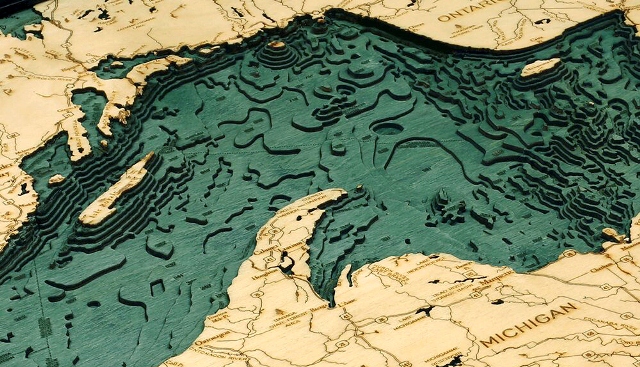
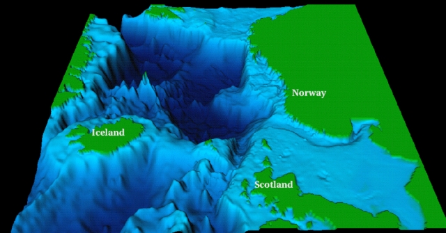
The term “bathymetry” originally referred to the ocean’s depth relative to sea level, although it has come to mean “submarine topography,” or the depths and shapes of underwater terrain.
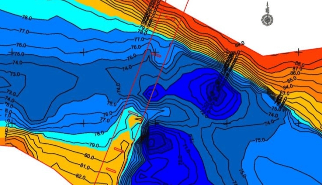
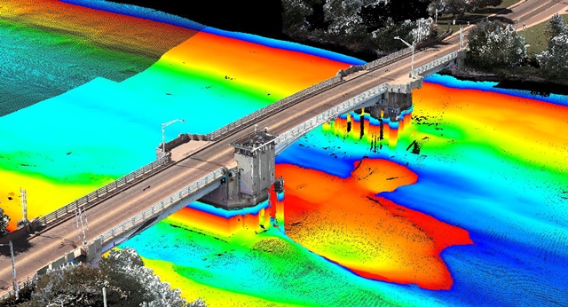
In the same way that topographic maps represent the three-dimensional features (or relief) of overland terrain, bathymetric maps illustrate the land that lies underwater. Variations in sea-floor relief may be depicted by color and contour lines called depth contours or isobaths.
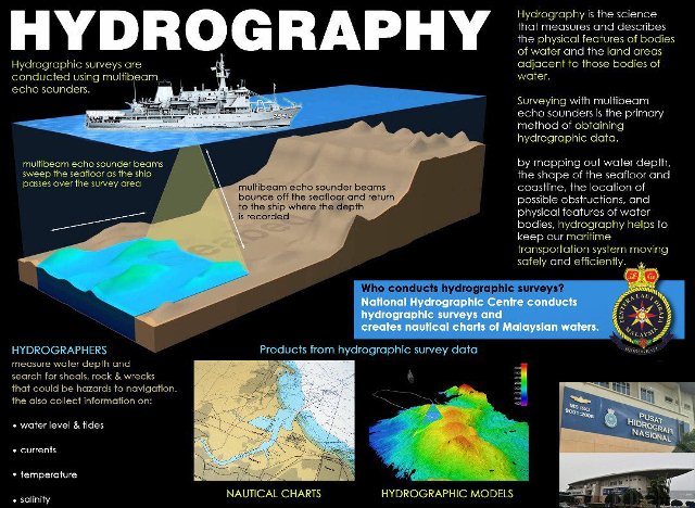
Bathymetry is the foundation of the science of hydrography, which measures the physical features of a water body. Hydrography includes not only bathymetry, but also the shape and features of the shoreline; the characteristics of tides, currents, and waves; and the physical and chemical properties of the water itself.
Bathymetric Survey Equipment
Bathymetry is the study of the underwater depth of lake or ocean floors. In other words, bathymetry is the underwater equivalent to hypsometry or topography.
Bathymetric or Hydrographic are both terms referring to submarine topography and are sometimes used interchangeably. The results from a hydrographic survey are normally plotted to produce a bathymetric contour map, which is a plan of the depth of the sea bed arranged in such a manner as to show lines of equal depth from the coastline. In a hydrographic survey, the actual measurement of the water depth is the easy part.
Hydrographic survey is the science of measurement and description of features that affect maritime navigation, marine construction, dredging, offshore oil exploration/offshore oil drilling and related activities. Hydrography is collected under rules which vary depending on the acceptance authority.
Acoustic Bathymetry Survey uses sonar (sound navigation and ranging) systems to collect depth information, using simple physics. Basically, a transducer emits a sound wave directly to the water’s floor and records the time for the sound wave to be reflected back after it strikes the bottom.
The variation in relief constitutes the morphology of the ocean floor. Charting of the ocean is very important for many reasons: it affects circulation, a potential site for living and non-living resources, submarine navigation, geophysical exploration, etc. In brief, bathymetry is the seafloor-relief.
LiDAR is a remote sensing technology that uses the pulse from a laser to collect measurements which can then be used to create 3D models and maps of objects and environments. LiDAR works in a similar way to Radar and Sonar yet uses light waves from a laser, instead of radio or sound waves.
Topographic Map definition
Topographic maps offer detailed information on a particular area and are used for several types of activities such as emergency preparedness, urban planning, resource development, and surveying to camping, canoeing, adventure racing, hunting, and fishing.
Underwater Topography Maps
Topographic maps of the seafloor. Detailed depth contours provide the size, shape, and distribution of underwater features. The map serves as a tool for performing scientific, engineering, marine geophysical and environmental studies, that are required in the development of energy and marine resources.