Professional Web Writer | Motor Enthusiast | Content Creator | Logan is a dedicated and skilled web writer, passionate about engines and machines and with a talent for creating engaging and informative content.
She specializes in writing about a diverse range of topics including construction, forklifts, heavy equipment, excavators, etc. SEO Optimization: Proficient in SEO best practices, ensuring high visibility and engagement for all published content.
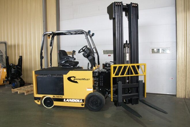
Swing Mast Forklift: Maximize storage space with articulated or swing mast forklifts. The innovative design allows these lift trucks to do the work of a standard reach truck in aisles up to 40 inches smaller. These specialty forklifts are ideal for any application, both indoors or outdoors, where space to maneuver is limited.
Articulated & swing mast forklifts can help you get the most out of your warehouse storage space, but there are other ways to optimize your warehouse design to ensure optimal efficiency.
Swing Mast Forklift
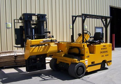
Narrow aisle forklift
This unit is specially designed for a very narrow aisles operation. Because it will turn sharply to the right (90 degrees) and can use it for your material handling without turning the whole forklift to the rack shelf/mesh direction.
You can simply drive this machine to the aisle (even in the narrow aisle as narrow as 6’/2 meters) and start working with its 90 degrees turn to the right easily. You can also use it for loading and unloading trucks if required. You can drive this machine outside also…but only of good days (no rain or snow ).
Narrow aisle forklift
Very narrow aisle forklift
If your warehouse has building support columns in the aisles, the Narrow Aisle Forklift is much more maneuverable than a turret truck, and additional pallet positions are regained.
New operators will find that it’s easier to learn to operate an articulated forklift than it is to learn to operate more complicated turret forklifts.
This is because narrow forklift requires fewer controls. The Very Narrow Aisle Forklift has the same number of hydraulic controls as most conventional forklifts, and in similar locations as conventional forklifts.
In order to limit the amount of sway in the mast at higher lift heights, turret, Drexel and swing reach trucks typically require much flatter floor tolerances than conventional concrete floors, according to the Design and Construction of Concrete Floors.
These floors are much more expensive as a result. In addition, to flatter floors, most systems require the use of expensive embedded guidance systems and guide rails.
Because the front end of the Flexi pivots, the load remains stable even on rough floors. This eliminates the need for flat floors and the added expense of guidance systems and rails.
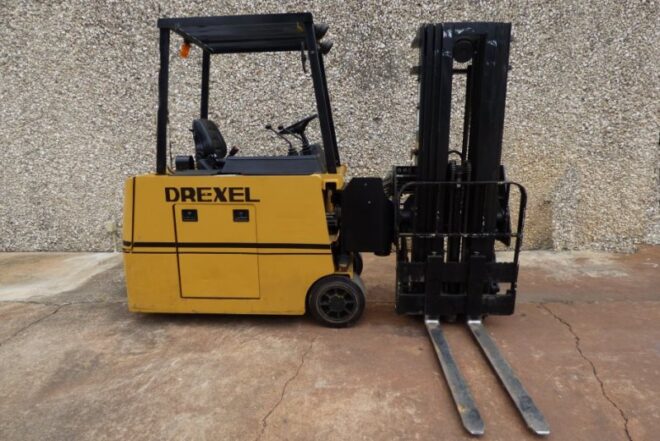
Swing Mast Forklift
Articulated forklift truck
Your investment in an articulated forklift will normally be about 50% of the cost of a turret truck. But your savings don’t stop there.
A turret truck “system” often requires very expensive flat floors, wire guidance systems, and/or rails on the floor. This adds substantially to the cost of the basic truck. An articulated forklift truck needs none of this. The cost of the articulated forklift is the cost of the system.
Using an articulated forklift very narrow aisle forklift will typically yield 85% to 90% of the number of pallet positions when compared to turret and swing reach trucks in the same amount of space. But the intersecting aisle required by a turret truck is about twice that of an articulated forklift, so some pallet positions are regained as a result.
Swing Mast Forklift
Swing Mast Forklift
Why Choose Articulating Forklifts Instead of Reach Trucks?
Very narrow aisle forklifts will typically store 15% to 20% more pallet positions than a reach truck can store in the same amount of space. This will significantly lower your cost per pallet position.
Is it easy to learn to drive an articulated forklift?
It’s much easier for a conventional truck operator to learn to operate an articulated forklift than it is to learn to operate a reach truck because the overall truck design and hydraulic levers are the same as conventional forklifts.
Is it expensive to maintain an articulate forklift?
An articulated forklift cost about 20% less to maintain than reach trucks. Most people will agree that maintenance expense is directly proportional to the number of moving parts. An articulated forklift has much fewer moving parts than a reach truck, and the parts are located where they are easier to access on an articulated forklift when service is required. The reach mechanism requires a lot of maintenance.
Is it easy to handle an articulated forklift?
An articulated forklift operator can see the load being handled better than a reach truck operator can see his load. This is because the articulated forklift operator will pick and place loads at a 90° angle to the machine. Visibility from the side is unobstructed when compared to a reach truck operator trying to see through the mast and reach mechanism. In fact, reach truck operators can often be seen leaning outside of the operator’s compartment to get a better view of the forks or the load being handled.
Forklift safety is of the utmost importance, and driving a forklift improperly presents various risks to both yourself and others, as well as your surroundings and the things you’re lifting.
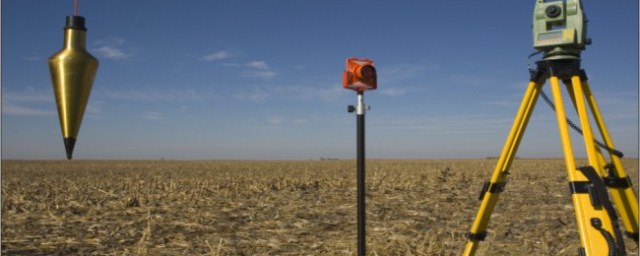
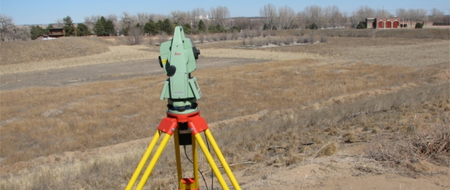
Topographic survey: Surveying has to do with the determination of the relative spatial location of points on or near the surface of the earth.
It is the art of measuring horizontal and vertical distances between objects, measuring angles between lines, determining the direction of lines, and of establishing points by predetermined angular and linear measurements.
Along with the actual survey, measurements are the mathematical calculations.
Distances, angles, directions, locations, elevations, areas, and volumes are thus determined from the data of the survey.
Survey data is portrayed graphically by the construction of maps, profiles, cross-sections, and diagrams
Topographic Survey Cost
Fundamentals of land surveying
The importance of the Surveying
Land surveying is basically an art and science of mapping and measuring land. The entire scope of the profession is wide; it actually boils down to calculate where the land boundaries are situated. This is very important as, without this service, there would not have been railroads, skyscrapers could not have been erected and neither any individual could have put fences around their yards for not intruding others land.
Topographic survey cost
Types of a survey in civil
Types of surveying
Geodetic Surveying:
The type of surveying that takes into account the true shape of the earth. These surveys are of high precision and extend over large areas.
Plane Surveying:
The type of surveying in which the mean surface of the earth is considered as a plane, or in which its spheroidal shape is neglected, with regard to horizontal distances and directions.
Different survey methods
Different methods of Surveying:
Control Survey: Made to establish the horizontal and vertical positions of arbitrary points.
Boundary Survey: Made to determine the length and direction of landlines and to establish the position of these lines on the ground.
Topographic Survey: Made to gather data to produce a topographic map showing the configuration of the terrain and the location of natural and man-made objects.
Hydrographic Survey: The survey of bodies of water made for the purpose of navigation, water supply, or sub-aqueous construction.
Mining Survey: Made to control, locate and map underground and surface works related to mining operations.
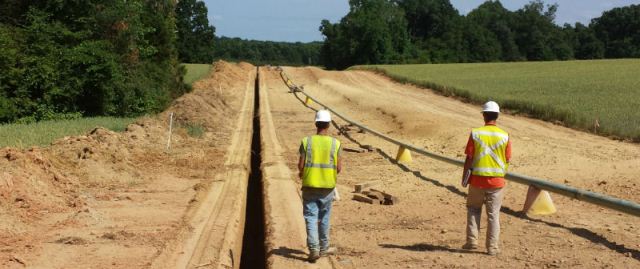
Construction Survey: Made to lay out, locate and monitor public and private engineering works.
Route Survey: Refers to those control, topographic, and construction surveys necessary for the location and construction of highways, railroads, canals, transmission lines, and pipelines.
Photogrammetric Survey: Made to utilize the principles of aerial photogrammetry, in which measurements made on photographs are used to determine the positions of photographed objects.
Astronomical survey: generally involve imaging or “mapping” of regions of the sky using telescopes. (Topographic survey cost)
English mathematician Edmund Gunter (1581-1626) gave to the world not only the words cosine and cotangent, and the discovery of magnetic variation, but the measuring device called Gunter’s chain shown below. Edmund also gave us the acre which is 10 square chains. The Gunter’s chain is 1/80th of a mile or 66 feet long. It is composed of 100 links, with a link being 0.66 feet or 7.92 inches long. Each link is a steel rod bent into a tight loop on each end and connected to the next link with a small steel ring.
Starting in the early 1900’s surveyors started using steel tapes to measure distances. These devices are still called “chains” to this day.
Topographic survey cost
Chain surveying procedure
Procedure of Chaining
It must be remembered in surveying, that under most circumstances, all distances are presumed to be horizontal distances and not surface distances.
This dictates that every field measurement is taken be either measured horizontally or, if not, reduced to a horizontal distance mathematically.
In many instances, it is easiest to simply measure the horizontal distance by keeping both ends of the chain at the same elevation. This is not difficult if there are less than five feet or so of elevation change between points. A hand level or “pea gun” is very helpful for maintaining the horizontal position of the chain when “level chaining.” A pointed weight on the end of a string called a “plumb bob” is used to carry the location of the point on the ground up to the elevated chain by simply suspending the plumb bob from the chain such that the point of the plumb bob hangs directly above the point on the ground.
When the difference in elevation along the measurement becomes too great for level chaining, other methods are called for. One option, “break chaining”, involves simply breaking the measurement into two or more measurements that can be chained level. (Topographic survey cost)
Electronic distance meter
Distance Measuring (Electronic Distance Meters)
In the early 1950s, the first Electronic Distance Measuring (EDM) equipment was developed. These primarily consisted of electro-optical (light waves) and electromagnetic (microwave) instruments. They were bulky, heavy and expensive. The typical EDM today uses the electro-optical principle. They are small, reasonably lightweight, highly accurate, but still expensive.
Purpose of chain surveying
Principle of Chaining
To measure any distance, you simply compare it to a known or calibrated distance; for example by using a scale or tape to measure the length of an object. In EDM’s the same comparison principle is used. The calibrated distance, in this case, is the wavelength of the modulation on a carrier wave.
Modern EDM’s use the precision of a Quartz Crystal Oscillator and the measurement of phase-shift to determine the distance.
The EDM is set up at one end of the distance to be measured and a reflector at the other end.
The EDM generates an infrared continuous-wave carrier beam, which is modulated by an electronic shutter (Quartz crystal oscillator).
This beam is then transmitted through the aiming optics to the reflector.
The reflector returns the beam to the receiving optics, where the incoming light is converted to an electrical signal, allowing a phase comparison between transmitted and received signals.
The amount by which the transmitted and received wavelengths are out of phase can be measured electronically and registered on a meter to within a millimeter or two.
Topographic survey cost
Measuring angles
Angle Measuring: Topographic survey cost
Measuring distances alone in surveying does not establish the location of an object. We need to locate the object in 3 dimensions. To accomplish that we need:
Horizontal length (distance)
The difference in height (elevation)
Angular direction.
An angle is defined as the difference in direction between two convergent lines. A horizontal angle is formed by the directions to two objects in a horizontal plane. A vertical angle is formed by two intersecting lines in a vertical plane, one of these lines horizontal. A zenith angle is the complementary angle to the vertical angle and is formed by two intersecting lines in a vertical plane, one of these lines directed toward the zenith.
Different types of angles
Types of Measured Angles
Interior angles are measured clockwise or counter-clockwise between two adjacent lines on the inside of a closed polygon figure.
Exterior angles are measured clockwise or counter-clockwise between two adjacent lines on the outside of a closed polygon figure.
Deflection angles, right or left, are measured from an extension of the preceding course and the ahead line. It must be noted when the deflection is right (R) or left (L).
Theodolite
A Theodolite is a precision surveying instrument; consisting of an alidade with a telescope and an accurately graduated circle, and equipped with the necessary levels and optical-reading circles. The glass horizontal and vertical circles, optical-reading system, and all mechanical parts are enclosed in an alidade section along with 3 leveling screws contained in a detachable base or tribrach.
Transits
A Transit is a surveying instrument having a horizontal circle divided into degrees, minutes, and seconds. It has a vertical circle or arc. Transits are used to measure horizontal and vertical angles. The graduated circles (plates) are on the outside of the instrument and angles have to be read by using a vernier.
Closed traverse procedure
Procedure for running a traverse: Topographic survey cost
To begin any traverse, a known point must be occupied. (To occupy a point means to set up and level the transit or theodolite, directly over a monument on the ground representing that point.) Next, a direction must be established. This can be done by sighting with the instrument a second known point, or any definite object, which is in a known direction from the occupied point.
The object that the instrument is pointed to in order to establish a direction is known as a backsight. Possible examples would be another monument on the ground, a radio tower or water tank on a distant hill, or anything with a known direction from the occupied point. A celestial body such as Polaris or the sun could also be used to establish an initial direction.
Once the instrument is occupying a known point, for example, point number 2, and the telescope has been pointed toward the backlight, perhaps toward point number 1, then an angle and a distance is measured to the first unknown point. An unknown point being measured is called foresight. With this data, the position of this point (let’s call it point number 100) can be determined.
The next step is to move the instrument ahead to the former foresight and duplicate the entire process.
GPS global positioning system
How satellite distance is measured
The Global Positioning System (GPS) is a navigational or positioning system developed by the United States Department of Defense. It was designed as a fast positioning system for 24 hours a day, three-dimensional coverage worldwide.
It is based on a constellation of 21 active and 3 spare satellites orbiting 10,900 miles above the earth. The GPS (NAVSTAR) satellites have an orbital period of 12 hours and are not in geosynchronous orbit (they are not stationary over a point on the earth). They maintain a very precise orbit and their position is known at any given moment in time.
This constellation could allow GPS user access to up to a maximum of 8 satellites anywhere in the world.
GPS provides Point Position (Latitude/Longitude) and Relative Position (Vector). GPS can differentiate between every square meter on the earth’s surface thus allowing a new international standard for defining locations and directions.
GPS satellite system
The Principles of GPS
For centuries man has used the stars to determine his position. The extreme distance from the stars made them look the same from different locations and even with the most sophisticated instruments could not produce a position closer than a mile or two. The GPS system is a constellation of Manmade Stars at an orbit high enough to allow a field of view of several satellites, yet low enough to detect a change in the geometry even if you moved a few feet.
A typical conventional survey establishes positions of unknown points by occupying a known point and measuring the unknown points. GPS is somewhat the opposite.
Topographic survey cost
GPS stands for a global positioning system
How satellite distance is measured
Each GPS satellite continually broadcasts a radio signal. Radio waves travel at the speed of light (186,000 miles per second) and if we measure how long it took for the signal to reach us we could compute the distance by multiplying the time in seconds by 186,000 miles per second.
In order to measure the travel time of the radio signal, the satellite broadcasts a very complicated digital code. The receiver on the ground generates the same code at the exact time and when the signal is received from the satellite, the receiver compares the two and measures the phase shift to determine the time difference.
Topographic survey cost
Differential GPS
To achieve sub-centimeter accuracies in positions, we need a survey-grade receiver and a technique called Differential GPS. By placing a receiver at a known location, a total error factor that accounts for all the possible errors in the system can be computed which can be applied to the position data of the other receivers in the same locale. The satellites are so high-up that any errors measured by one receiver could be considered to be exactly the same for all others in the immediate area.
Boundary and topographic survey cost
Differential leveling
Differential leveling is the process used to determine a difference in elevation between two points. A Level is an instrument with a telescope that can be leveled with a spirit bubble. The optical line of sight forms a horizontal plane, which is at the same elevation as the telescope crosshair.
By reading a graduated rod held vertically on a point of known elevation (Bench Mark) a difference in elevation can be measured and a height of instrument (H.I.) calculated by adding the rod reading to the elevation of the benchmark. Once the height of the instrument is established, rod readings can be taken on subsequent points and their elevations calculated by simply subtracting the readings from the height of the instrument.
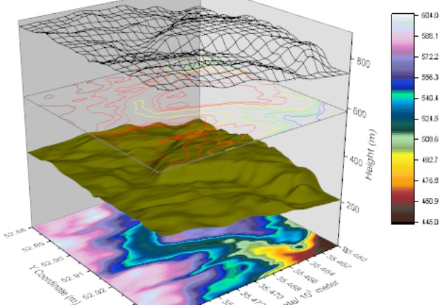
Digital terrain model
A digital Terrain Model (DTM) is a numerical representation of the configuration of the terrain consisting of a very dense network of points of known X, Y, Z coordinates. Modern surveying and photogrammetric equipment enable rapid three-dimensional data acquisition. A computer processes the data into a form from which it can interpolate a three-dimensional position anywhere within the model.
Think of a DTM as an electronic lump of clay shaped into a model representing the terrain. If alignment was draped on the model and a vertical cut made along the line, a side view of the cut line would yield the alignment’s original ground profile. If vertical cuts were made at right angles to the alignment at certain prescribed intervals, the side views of the cuts would represent cross-sections. If horizontal cuts were made at certain elevation intervals, the cut lines when viewed from above would represent contours.
A DTM forms the basis for modern highway location and design. It is used extensively to extract profiles and cross-sections, analyze alternate design alignments, compute earthwork, etc.
Topographic survey cost
Topographic cross-section
Cross-sections are lines 90 degrees perpendicular to the alignment (P-Line, L-Line, the centerline of stream, etc.), along which the configuration of the ground is determined by obtaining elevations of points at known distances from the alignment.
Cross-sections are used to determine the shape of the ground surface through the alignment corridor. The shape of the ground surface helps the designer pick his horizontal and vertical profile. Once the alignment is picked, earthwork quantities can be calculated. The earthwork quantities will then be used to help evaluate the alignment choice.
In addition to earthwork calculations, cross-sections are used in the design of storm sewers, culvert extensions and the size and location of new culverts.
Topographic survey cost
What is called topography?
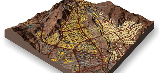
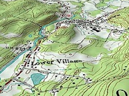
The topography is a detailed map of the surface features of the land. It includes the mountains, hills, creeks, and other bumps and lumps on a particular hunk of earth. Topography represents a particular area in detail, including everything natural and man-made — hills, valleys, roads, or lakes.
What is a topographic cross-section?
A topographic profile is a cross-sectional view along a line drawn through a portion of a topographic map.
What is Levelling in surveying?
Leveling is a process of determining the height of one level relative to another. It is used in surveying to establish the elevation of a point relative to a datum or to establish a point at a given elevation relative to a datum
What are the main objectives of surveying?
To determine the relative position of any objects or points of the earth. To determine the distance and angle between different objects. To prepare a map or plan to represent an area on a horizontal plane. To develop methods through the knowledge of modern science and technology and use them in the field.
While most people think of land surveys in the most basic sense—that is, the drawing of the boundaries of property—there are actually many different ways of surveying that service many different industries.
Topographic maps offer detailed information on a particular area and are used for several types of activities such as emergency preparedness, urban planning, resource development, and surveying to camping, canoeing, adventure racing, hunting, and fishing.
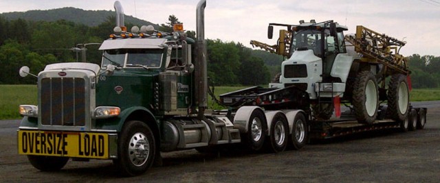
Heavy Equipment Hauling: Trailer Options for Hauling Construction Equipment. Consider carefully all your options for hauling your construction equipment. Use too much trailer, and you’re wasting money. Skimp on your trailer choice, and you risk a big headache.
Your equipment’s dimensions determine the type of trailer you should use for transportation. Smaller pieces of construction equipment ship on flatbed trailers. Medium-sized machinery fits on step-deck trailers. Larger pieces require Removable Gooseneck (RGN) trailers for safe shipping.
Heavy Equipment Hauling
Heavy machinery transport
Signs You Need A Professional Heavy Equipment Hauler
Load size large
The transportation of any large, heavy equipment presents unique challenges, where trying to use the company truck and trailer simply won’t get the job done. The proper handling of these oversized machines is essential to preserving the state of your equipment as well as the safety of everyone else out on the roads.
On top of this, heavy haul freight requires certain transportation equipment and vehicles in order to meet legal requirements such as axle restrictions.
Heavy Equipment Hauling
Transporting heavy machinery
Distance: The length of your heavy equipment haul can also lead to many logistical challenges for you and your company if attempting to do so using your own means. In order to ensure that everything goes smoothly during your cross-country heavy equipment transportation, you should lean on a company that has been there and done that — time and time again.
One of the biggest concerns contractors face is the on-time delivery of their cranes and other heavy construction equipment in time to start their projects. When you trust a reputable heavy equipment hauling company with this task, it takes the weight off your shoulders and gives you more peace of mind knowing you have a team with a proven track record for prompt delivery bringing your equipment to you.
Heavy Equipment Hauling
Transport and logistics requirements
Permit requirements
Another aspect of heavy equipment hauls is obtaining the proper documentation and permits prior to transporting. Most states require freight to have a permit for the machinery traveling on their highways and depending on the time of year, there can be limited travel hours or additional permits required depending on which states your heavy equipment will be passing through.
Transport heavy equipment cost
No matter what size your business may be, you likely don’t enjoy seeing money go out the window on unnecessary costs. While transportation is an unavoidable cost with any industry utilizing heavy equipment, there is certainly a multitude of ways to ensure you aren’t spending any more than you have to.
Use proved load and transport techniques that not only ensure the safest and most efficient superload deliveries, but they also cut out the unnecessary costs that you might run into at another company or when attempting to transport heavy equipment by your own means.
Heavy Equipment Hauling
All size equipment transport
Trailer suggestions for transporting construction loading equipment include:
Backhoe Loaders: (flatbed, step deck, RGN) Match the size of the backhoe to the proper type of trailer. Most backhoes travel on RGN trailers because step-deck ramps are too steep to navigate.
Forklifts: (flatbed, step deck, RGN) Smaller warehouse forklifts fit on flatbed trailers, as long as you can load them. Telehandlers usually travel on step-deck trailers. Rough terrain forklifts need RGN trailers.
Skid steers: (flatbed, step deck) Relatively compact, skid steers are pretty easy to ship. They usually fit on flatbed trailers, if they’re less than 8-½ feet tall. Topdeck of a step-deck trailer is a great spot too.
Wheel Loaders: (step deck, RGN) Small wheel loaders are backed onto step-deck trailers from the rear of the trailers. Larger wheel loaders are driven onto RGN trailers from the front of the trailers.
Heavy Equipment Hauling
Construction equipment hauling
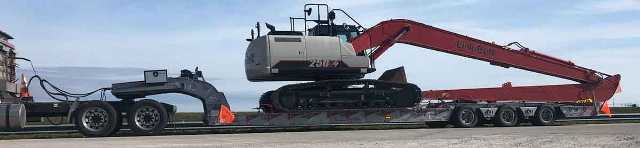
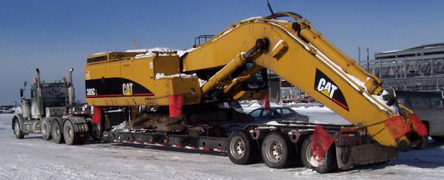
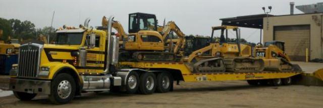
For the largest pieces of construction equipment, specialized RGN trailers are required. We’re talking multi-axle, extended length trailers. Bulldozers usually can fit on regular RGN trailers. Street sweepers come in all shapes and sizes, so you’ll have to match your equipment with the right trailer type.
Trailer suggestions for shipping heavy construction equipment include:
Street Sweepers: (flatbed, RGN) If your street sweeper is too big for a flatbed trailer, it’s likely too big for a step-deck trailer. Step-deck trailers handle around 45,000 pounds; larger gear must travel on an RGN trailer.
Bulldozers: (step deck, RGN) Small bulldozers fit on step-deck trailers. Larger bulldozers require RGN trailers. You back a bulldozer onto a step-deck trailer, but you drive it forward onto an RGN trailer.
Graders and Scrapers: (RGN) Motor graders and motor scrapers can be gigantic, too big to haul. Your smaller motor graders and motor scrapers fit on an RGN trailer. Expect wide load designation.
Articulated Trucks: (RGN) Big off-road dump trucks always travel as oversize loads. You’ll need a specialized trailer to haul an articulated dump truck, with extra axles and enhanced suspension.
Heavy equipment shipping
Shipping Earth Digging Equipment
Most earth-digging equipment is used for utility work. Trenchers create the ditches in which pipelayers deposit their pipes. Due to their versatility and maneuverability, mini-excavators have become extremely popular. Full-size excavators are standard equipment on most construction sites.
Trailer suggestions for hauling earth digging equipment include:
Trenchers: (flatbed, step deck, RGN) Walk-behind trenchers fit easily on a flatbed trailer. Larger trenchers, like Ditch Witches, need step-deck trailers. Self-propelled trenchers ride on RGN trailers.
Mini Excavators: (flatbed, step deck) Smaller mini-excavators usually travel aboard a flatbed trailer. Larger mini-excavators fit on step-deck trailers, but you’ll need ramps to get them loaded.
Excavators: (flatbed, RGN) Smaller excavators can travel aboard a flatbed trailer. If your excavator is too big to fit on a flatbed trailer, it’s likely too large for a step-deck trailer. An RGN is your best bet.
Pipe Layers: (RGN) These crane-like machines are wide, tall and long. They’re heavy, too. Most pipelayers travel as oversize loads on specialized RGN trailers. Their dimensions make them difficult to handle.
Heavy Equipment Hauling
Heavy equipment shipping overseas
How to ship machinery and parts
To successfully ship machinery and machine parts, you must determine the right packaging, mode, and carrier.
Know your machinery. To start the process, assess the item you’re choosing to ship. Take note of product dimensions, weight and any other features that could impact freight capacity. Understand the type of machinery you are shipping and research how carriers have moved items like yours in the past. If what you are shipping is uncommon, use what you know about a similar item to anticipate your needs and restrictions.
Package properly. Machinery often brings about more packaging regulations than other shipments. You must balance your shipping needs with the packaging requirements of your carrier.
For example, some carriers require all machinery shipments to be crated. You’ll need to add crating costs to the final price to use these carriers.
Know what prep work or loading equipment will be required before packaging your machinery. Heavy equipment often requires lifts and loading dock access in order to get it on the truck.
Identify the appropriate mode. While some machinery and machinery parts are small enough in size and quantity to be assigned to LTL, others are much larger and will require a different transportation mode. In these instances, it’s important to consider truckload or flatbed options as well.
Find the right carrier. Finding the right carrier requires you to combine what you know about your machinery shipment with the most relevant carrier you can find. This may be difficult depending on the contents of your shipment. You’ll want to find a specialized carrier specific to the kind of machinery you plan to ship.
For example, if you need to ship an x-ray machine, find a carrier that specializes in shipping medical machines. This increases efficiency and reduces the chance of damages or unexpected costs
Heavy Equipment Hauling
Heavy Equipment Hauling
How much does it cost to transport heavy equipment?
The cost to transport heavy equipment varies greatly based on the equipment being transported. The cost to ship heavy equipment longer distances, over 500 miles, averages $1.75 per mile, while shorter distance shipments average $5.00 per mile.
What is heavy haul trucking?
In the U.S. a superload is a truck tractor with an attached trailer that has an over-dimensional or overweight object (the load) on it that exceeds the ordinary permit limits commonly associated with oversize or overweight loads.
What is hauling in construction?
Hauling heavy, large loads requires the use of hauling in construction. There are several different types of hauling equipment that can be used for building and construction. Some of the most typical types include cranes, bulldozers, forklifts, dump trucks, and excavators, as well as many others.
What do hauling companies do?
For hire, truckload carrier is a classification of trucking companies within the trucking industry that earns their revenue by hauling other companies freight. Typically, for-hire truckload carriers will contract out their trucks, trailers, and drivers to another company that needs their services.
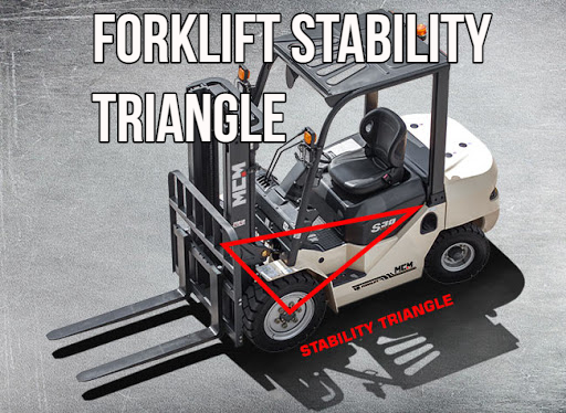
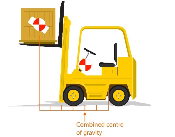
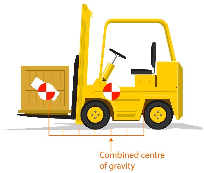
Forklift Stability Triangle: Making sure your forklift remains stable is one of the most important things you need to do while it’s in use. Unstable forklifts are the cause of many injuries and deaths each year when they fall on operators.
Forklift Stability Triangle
Forklift triangle of stability
Generally speaking, your forklift truck will stay stable as long as it’s properly loaded and is operated carefully by a professional driver. This is why it’s important that forklifts are not operated by anyone who doesn’t know what they’re doing and doesn’t understand what the truck can and can’t do.
Trucks themselves are very safe and secure when loaded and operated properly, and there’s no need to worry as long as you follow the appropriate rules and instructions. As a general rule, your truck’s stability will depend on its weight, height, speed, and distance. (Forklift Stability Triangle)
Forklift Stability Triangle
Average weight of a forklift
The weight of your truck is one of the main factors in determining its stability – Forklift Stability Triangle:
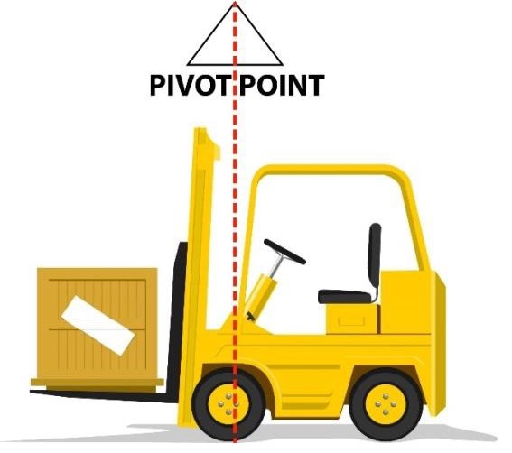
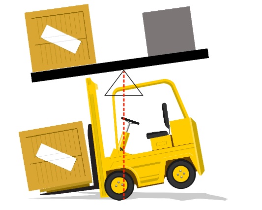
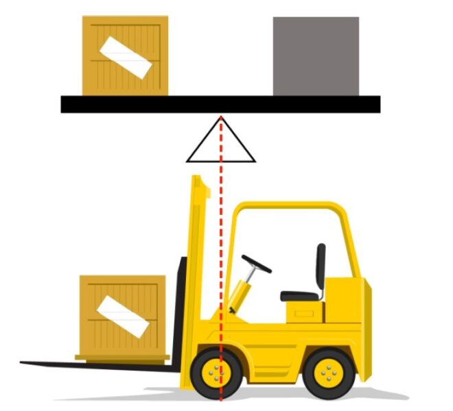
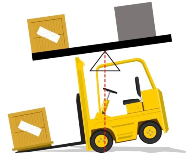
If you think of it as a seesaw, you will be able to understand that the back end of the truck must always be heavier than the load it carries. If the load should be the same weight or heavier than the truck itself, the truth is in danger of tipping over.
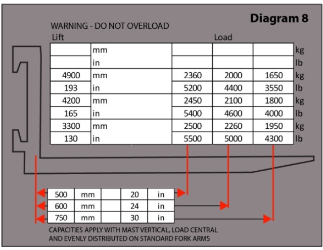
You can avoid this by always paying attention to the lifting capacity of the truck and ensuring you never exceed it. You can see the load center on the data plate which is fixed to your truck, and you can also see any differing load centers showing what you can lift and how.
Forklift Stability Triangle
Forklift lifting height
The height at which your load is raised affects the center of gravity and therefore the stability of your forklift.
Simply put, when you need to lift your load, you should move very carefully and aim to move only when you have to – mainly when loading or unloading, and not raising the load while driving.
Failure to observe this rule could lead to injury, broken goods, and other serious damage.
Forklift speed limit
No unnecessary speed should be used when operating your truck. While you need to drive efficiently, you should not be moving around at speeds which could cause your forklift to become unstable.
Speed affects the weight of your load, increasing it the faster you go. If you’re already carrying a heavy load, making it heavier will cause it to become unstable in exactly the same way as if you had overloaded it.
This can cause the truck to tip over, a danger which must be avoided.
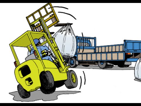
Distance is yet a further factor that could cause your forklift to tip over if safety rules are not properly observed.
If you bear in mind the seesaw analogy as previously mentioned, and the tipping effect it can have on your truck.
Taking a look at what happens when a load is moved away from the truck’s fulcrum (see diagram 6) you’ll see that it’s not been set by the carriage or the backrest of the truck.
You could then find the truck tipping over forwards, causing breakages and expensive damage, so always pay attention to the distance.
Forklift Stability Triangle – If your truck tips:
Should your truck tip at all, you must follow the right safety procedures. This means staying in the truck, holding on tight, bracing your feet and leaning away from the point of impact. Trying to jump out of the truck could cause you to be put in even greater danger.
Forklift data plate explained
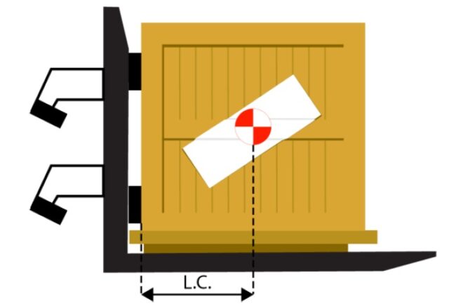
Load center – Forklift Stability Triangle:
Always check your data plate for the information about the distance from the heel to the back of the forks outwards to the center of gravity.
You can also see on some forklifts how much you can lift and at what load centers.
Remember that the weight of the load indicated on the truck’s capacity plate is MAXIMUM. It must NEVER be exceeded and in some applications the actual load handled should be considerably less.
Forklift on road requirements
The following are some general rules you should always follow in order to safely operate a forklift.
Only operate vehicles you are trained and authorized to operate
Read the manufacturer’s instructions thoroughly before you attempt to operate any vehicle
Carry out thorough and proper safety checks every time you use the vehicle
If you feel tired or unwell, or you have been drinking or taking medication, do not drive any vehicle
If you need glasses to drive, make sure you don’t operate a vehicle without them
Wear hard hats and any other appropriate safety equipment you need
Always wear a seat belt
Familiarise yourself with the signs and road markings wherever you’re working
Note any height restrictions for your vehicle in the place you’re working
Give clear and timely signals to other people working in your area
Observe other people’s signals too
Check your way is clear before you move off
Forklift rules and regulations
Drive on the left wherever you can, unless it’s safer to drive in the middle for better visibility
Slow down at junctions or crossings and sound your horn several times
Take care to avoid pedestrians no matter who has right of way
Drive at an appropriate speed and with due caution
Make sure nobody is underneath your forks at any time
Do not allow anyone to mount your forks at any time
Take care to look out for any objects in your way
Keep a safe distance from any other vehicles
In case of a tall load blocking your view, drive backward while looking where you’re going
If a load is in danger of collapsing, leave and tell a supervisor before trying to de-stack it
Always keep your head and limbs inside the truck when driving
Drive at a safe speed ensuring you have time for emergency stops if needed
Observe ground surfaces to check whether they may be unsuitable for your truck
Drive with loads as close to the ground as possible
If you’re not carrying a load, raise your forks clear of the ground while driving
Forklift operator key responsibilities
If driving outside without a load, always tilt your forks back
Tilt your forks back when carrying a load
If you can’t see properly when going up a slope, ask for assistance
When going downhill without a load, the forks should face down
Carry the load facing upwards if you need to go up a slope. When no load is carried, the forks should be downhill.
Tilt the forks backward and raise them above the ground when on a slope
Stick to a safe speed when on a slope
Never turn when on a slope
Drive at a 45-degree angle across bumps, railway lines, sleeping policemen, etc.
Never stack while on a slope
Never leave a forklift unattended on a slope
If you need to leave a forklift on a slope in an emergency, the wheels should be wedged securely
Always check the load weight, weight limit, and load center before picking up a load
If you’re in danger of exceeding any limits, reduce the weight or get a forklift with a larger weight capacity
Enter the load from the wide side wherever possible
Insert and space the forks properly for the particular load width and type
Take extra care if the tips of the forks
Which side of the forklift is supporting more of the red boxes weight?
The load size, position, and weight distribution critically affect the forklift’s capacity and the stability of the truck. Consider the following factors before engaging a load: -Weight, Size, and Position -Safe Load Capacity -Maximum Load Moment -Balance -Stability.
Stand-up forklifts (also known as stand-on and electric riders) are designed for applications where the operator must get on and off the lift truck frequently. They are more maneuverable and need less space to operate than sit-down forklifts.
Types of Topographical Survey: From the hydrographic point of view a Topographic Survey consists of a series of tasks carried out with the aim of determining the composition of those parts of the earth’s surface which emerge from the water.
It includes the coastal relief and the location of permanent natural or artificial objects and features. Such information is partly obtained by determining the position of points on the ground, which allows their shape as well as details of the features to be depicted, enabling their location and description to be charted. Other sources of data include remote sensing processes from aerial photogrammetric information, other airborne sensors or satellite imagery products.
In these cases, it is necessary to create ground control points in order to adjust the information to the reference frame in use.
Types of Topographical Survey
Types of topography
The term topography often has other applications, for example in oceanography it is used to depict seafloor surfaces or the boundaries of certain water mass characteristics. All these meanings share a common external description of surfaces covering a physical body.
This chapter deals with the methods applicable to the description of coastal features as part of hydrographic surveys, particularly with regards to the appearance of the ground and the location of detail.
It includes coast lining and location fixes, generally related to the high water line for marine surveys, the information on these areas ranges from this line to the low water line, as well as conspicuous coastal features which allow the mariner to position himself relative to nearshore dangers.
Except in harbors or coastal areas, where operations or projects are planned or expected to be undertaken, it is necessary to make detailed observations of coastal formations by topographic survey methods.
Types of Topographical Survey
Topographic survey
In some cases, much of the topographic surveying may be undertaken via photogrammetric processes. In these surveys, control is achieved by positioning details on the ground which may be identified in images.
Additionally, it is necessary to add information which may provide a proper interpretation of the structure of coastal features.
In coastal topographic surveys, it is also essential to locate all aids to navigation within the surveying area; if required, the horizontal and vertical geodetic control network should be made denser. In all these cases, it is essential that the reference system for the topographic survey co-ordinates, the geodetic control, and aids to navigation (reference stations, lights, beacons, etc.) is consistent with the reference system used for the rest of the hydrographic survey.
This precaution is fundamental for the mariner, who positions himself with the use of the aids to navigation and other coastal details, to be able to rely on the charted depths at every fix.
This chapter will deal first with the methods applied to land surveying, then it will deal with remote sensing ranging from photogrammetric processes to satellite imagery.
Triangulation survey
It is a technique based on principal angular measurements. Before the middle of the 20th century, it was the most common method for establishing geodetic control networks and for sole calculation of conspicuous points, marks and other aids to navigation or photogrammetric ground control points. Since the 1960s Electronic Distance Measuring equipment (EDM) or Electro-Optical Distance Measurement (EODM) has superseded the above methods. More recently they have been replaced by satellite methods, particularly since a permanent global coverage was established in the 1990s
The earliest form of triangulation for hydrographic purposes consisted of a series of observations, with a relatively small number of measured sides (baselines) and a large number of angular measurements, which are showed here with the observed directions. Such a diagram provides a great deal of redundancy; each double-diagonal quadrilateral has three angular verifications created by adding or subtracting values. Nevertheless, the network scale is still determined by the baselines.
Types of Topographical Survey
GNSS observations
In old unconnected geodetic controls, position and orientation were established from astronomic observations of latitude, longitude, and azimuth in a datum. Nowadays, if marks are used from these kinds of networks, it is usually necessary to re-observe and recalculate via GNSS in order to convert coordinates into a universal system like WGS 84.
In general it should be noted that distances from the baselines could be measured within accuracies ranging from 1ppm to 3ppm, directions from ± 0.5″ to ± 2″, and transition from a base to another (that is, the contrast between the base transfer by triangle resolution and the other measured base) could normally be checked within 20 ppm and 40 ppm.
These limitations should be taken into account when trying to adjust an old triangulation network to a present framework via GNSS observations, with distances of 200 or 300 km there can be differences of several meters (2 or 3).
Besides tolerating differences of these orders, it is necessary to have a sufficient number of well-distributed connections to common datums and of datum conversion algorithms in order to absorb the distortions typical of the old networks.
Notwithstanding the above statement, densification by GNSS of datums with fixed co-ordinates computed from old triangulations should be avoided; such cases often lead to distortions and inaccuracies in the final results. If unavoidable due to the need to keep the coordinates of an old datum, it will be necessary to adopt very particular computation strategies and the limitations of the values obtained must be stated at an early stage.
Boundary survey
The most common and well-known surveys conducted today are boundary surveys, mortgage surveys, and topographic surveys. An ALTA survey, which is actually a shortened title for ATLA/ACSM, combines elements of all three with a set of standards put forth jointly by the American Land Title Association and the American Congress on Surveying and Mapping.
ALTA surveys are most commonly used for commercial properties; by having a universal standard, companies can assure themselves of the level of thoroughness and be confident when the results are guaranteed by an ALTA survey.
Boundary survey definition
Boundary Surveys are exactly what the name describes: a survey to establish the true boundaries of a given property.
Through previously recorded markers and the establishment of new landmarks, a surveyor will establish the true boundaries of a property and then mark the corners and lines of the plot, using markers such as iron rods, pipes or concrete monuments in the ground, or nails set in concrete or asphalt. In the past, trees, piles of stones other less permanent markers were used, which led to confusion when the markers were either destroyed or changed.
Boundary and topographic survey cost
While most people think of land surveys in the most basic sense—that is, the drawing of the boundaries of property—there are actually many different ways of surveying that service many different industries. Property surveys are a large part of the business, but there are also surveys and surveyors that help the construction industry, the environmental sector, and many others.
The kinds of surveys that are conducted would surprise most people, and some things that you might think are surveys aren’t surveys at all. Instead of the standard two-dimensional measuring from one point to another, today’s surveys not only measure the land, but also the air and water above and below us. Let’s take a quick look at a sampling of different types of land surveys available.
Types of topographical survey
Mortgage survey
Mortgage Surveys are simple surveys that for the most part determine land boundaries and building locations. They are usually required by title companies and lending institutions when they provide financing to show that there are no structures encroaching on the property and that any structures on the property meet current zoning and building codes.
It is important to ensure that you are getting an officially licensed mortgage survey performed by a licensed land surveyor, and not a mortgage inspection, which is a substandard survey that does not adhere to any set standards and is not regulated or accepted as an official land survey.
Topographic Surveys are land surveys that locate natural and man-made features on a piece of property—for example, buildings, improvements, fences, elevations, land contours, trees, and streams.
These are measured for their elevation on a particular piece of land and presented as contour lines on a plot. Topographical surveys are sometimes required by the government. Engineers and architects also use topographical surveys to aid in the design of improvements or developments on a site.
Types of Topographical Survey
Construction survey
One of the largest and most rapidly growing areas of land surveying is in the construction industry. Surveys are crucial tools from inception and planning to actual construction and maintenance afterward.
Most construction surveys fall under the discipline of civil engineering, which may require additional degrees and certifications in order to conduct.
All construction projects begin with the Plot Plan or Site Plan, which set out the plan for the entire project including all existing and proposed conditions on a given site.
As-Built Surveys are conducted several times during a construction project to verify for local and state boards that the work authorized is being completed to the specifications set on the plot plan.
A Foundation Survey is a type of as-built survey that collects the positional data on a foundation that has been poured and is now cured.
Foundation surveys are done to ensure that the foundation has both been constructed in the proper location and has been built in the proper manner according to the plan.
For existing structures, a Deformation Survey determines if a structure or object is changing shape or moving. By the taking of three-dimensional positions on specific points on an object, then letting a period of time pass before retaking and measuring the points, it can be determined whether a structure is shifting or moving, and by how much.
what is a topographical survey?
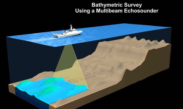
Hydrographic survey
Although it may seem counter-intuitive, land surveyors are also responsible for performing Hydrographic and Bathymetric Surveys. Hydrographic surveys collect data relating to any body of water, and the data collected may include the water depth, bottom contours, the direction of the current, observing and recording high watermarks and water levels, as well as location of fixed objects and landmarks for navigational purposes.
They can also be conducted to gather information for engineering or resource management purposes, such as hydropower plants. Bathymetric surveys deal exclusively underwater and map the seabed profile.
what is a topographical survey
Geodetic survey
Geodetic Surveys fall under both the land and water category, as they map out the shoreline. Thomas Jefferson commissioned a geodetic survey in 1807 as the Survey of the Coast. Progress on the survey moved slowly at first as they did not even have the proper instruments to perform the survey until 1815.
It still exists today as the National Geodetic Survey, and its responsibilities now include the interior lands of the United States as well as its coasts.
Wetland delineation
Wetlands Delineation and Location Surveys belong in a category all on their own; they are performed when construction work is being planned on or near a site containing defined wetlands. Local, state, or federal regulations vary, but wetlands are usually classified as areas that are completely inundated with water for more than two weeks during the growing season.
Boundaries of wetlands are determined by observing the soil colors, vegetation, erosion patterns or scour marks, hydrology, and morphology of the land in question. Data is then collected on the locations of the placed flags and a plan is drawn to reference the boundary of the wetlands and compare it to the proposed boundaries of the surrounding plots or parcels of land and the construction work proposed within.
There are many other types of land surveys, but the examples presented above are the most common forms of land surveys that the general public is most likely to encounter.
what is a topographical survey
Types of Topographical Survey
What is included in a topographic survey?
Features typically shown on a topographic survey include trees, slopes and changes in elevation, streams and rivers, streets and walkways, buildings, fences and walls, manholes, utility poles, and more.
What is a mortgage survey?
A mortgage survey is one type of survey you might have done on a piece of property you want to purchase. While a physical inspection focuses on the condition of the building, a mortgage survey investigates the property itself. Other reports include land surveys conducted by licensed land surveyors
How much is a topographic survey?
A topographic review ranges from $500 to $1,200 for a lot size less than 10,000 square foot. It locates both man-made and natural features such as streams, trees, elevations, fences, and buildings. Governmental agencies, architects or engineers may require it before lot development.
What are the difference in a property boundary survey and a topographical survey?
Boundary surveys are typically performed to obtain building permits, to resolve property disputes, and for erecting fences. A topographic survey locates all improvements and topographical features such as elevations of the land, embankments, contours, trees, watercourses, roads, ditches, utilities, etc.
What are land surveys?
Surveying or land surveying is the technique, profession, art and science of determining the terrestrial or three-dimensional positions of points and the distances and angles between them. A land surveying professional is called a land surveyor.
Topographic maps offer detailed information on a particular area and are used for several types of activities such as emergency preparedness, urban planning, resource development, and surveying to camping, canoeing, adventure racing, hunting, and fishing.
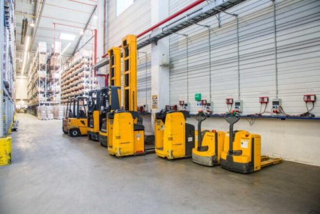
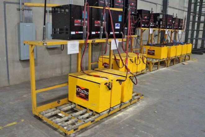
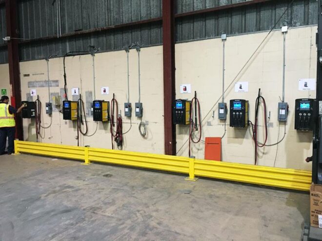
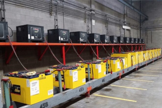
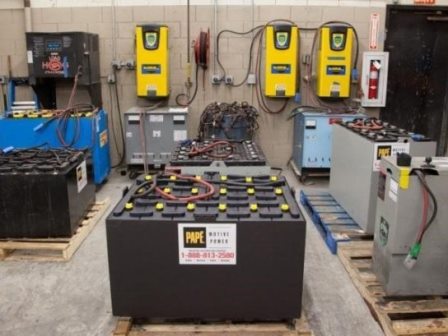
Forklift Battery Charger: Your forklift truck will run on its own battery if it’s an electric vehicle. The battery is a vital piece of equipment and must be cared for and kept charged in order for your truck to work properly.
While an engineer is responsible for the care and replacing of the battery itself, as the operator it’s your duty to take the battery into account when doing your daily checks and any general maintenance.
Caring for the battery extends its life, meaning they don’t need to be replaced as often. Because replacement batteries are very expensive, your employer will appreciate you treating it properly.
In addition, without a battery, you can’t use your forklift truck at all, which means your workplace is less productive and again costs your employer money in lost time.
Forklift Battery Charger
Forklift charging station
Forklift Battery Charger – There are some basic safety rules to observe when dealing with batteries.
The first is to ensure you never ever smoke close to the area where you charge your battery. And don’t use your lighter, or any other naked flame, to check the battery level. Batteries are highly flammable and if in doubt you should keep any and all forms of fire away from them.
Batteries also contain acid, which is highly corrosive if it comes into contact with your skin. For this reason, there should always be a supply of clean water close by wherever you’re using the forklift. If anyone should come into contact with the acid from a battery, they should rinse themselves thoroughly and seek a first aider immediately.
Forklift Battery Charger
Forklift battery charging instructions
exide forklift battery charger manual:
If you ever need to check or handle the battery, it is highly recommended that you should wear protective clothing including safety glasses and gloves while doing so. You should also disconnect the battery from the truck or the charger before you inspect or handle it.
To make sure you’re not at risk of injury including electric shocks, you should make sure any loose metallic objects are kept away from the battery completely. This means tucking in or removing dangling jewelry or watches, and making sure any metal objects or tools are removed from your top pockets.
A general rule to observe is that the manufacturer’s instructions should be followed throughout both maintenance and care of your battery.
Forklift Battery Charger
Forklift battery charging station
Charging Procedure:
Your forklift truck, if used as much as they tend to be in a busy warehouse or other business, will need to be recharged daily or even more often.
As the operator of the forklift, this job will usually fall to you to take care of.
To recharge the battery, you should first disconnect it from the truck and then remove the battery cover. Any gas coming from the battery will this way be released into the air instead of building up and causing a hazard while charging.
Forklift Battery Charger
How to put water in a forklift battery?
Forklift Battery Charger: Your battery should indicate what the electrolyte levels are in each cell, and you will need to check the levels to see if they need to be charged any further.
To charge the battery, add distilled water until it only just covers the plates but without overfilling. You should clean up any excess water right away and add the cell tops back on again.
There are some basic checks you need to do before you begin the charging process itself. You should make sure the charger is switched off and then look closely at the cables and plugs to see if there is any damage. If you don’t see any problems, you can then connect the charger to the battery.
Please bear in mind that while the majority of batteries are charged this way, every battery is slightly different, and you should follow the manufacturer’s instructions very closely at every step of the charging process.
When the battery has been fully charged, you should always turn the charger off before you disconnect it from the battery. This means there’s a minimal chance of accidental electric shocks.
The battery tops should be completely dry and securely fasted to the battery. Reconnect the battery to the truck and do any further securing or locking in place required by your particular forklift and battery.
Forklift Battery Charger
Forklift battery charging safety
Extra precautions – Forklift charging safety:
When charging your battery, you should only ever use water that has been distilled, or has been formulated especially for the purpose of charging your battery.
Containers should be made of glass or non-metallic material and should be kept clean and dry. If you notice your container is corroded, it should be neutralized using diluted ammonia or a sodium bicarbonate solution.
You can prevent corrosion from happening by training and drying the container, and then covering the battery terminals with petroleum jelly followed by acid proof paint where appropriate.
The vent holes should always be clear, and the cell tops tightly fitted, and the battery should be stored in a cool, dry place when not in use.
Forklift Battery Charger
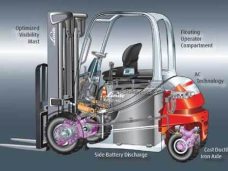
Electric forklift vs diesel forklift
Diesel and LPG Engines
Any trucks that aren’t powered by electric batteries have their own safety and maintenance procedures which must be followed at all times.
These general rules will help you to stay safe and keep your vehicle in good condition during refueling of diesel or LPG engines.
Make sure the building or room you’re in is well ventilated if you’re indoors
Always make sure you use your vehicle in a big enough space – no confined spaces
When it comes to refueling, only ever do this outdoors
Ensure no smoking signs are placed in areas where these vehicles will be used or refuelled
Switch off the engine when you’re refuelling the vehicle
Change any LPG cylinders outside or in well-ventilated areas only
Disconnect LPG cylinders only when the valve is firmly shut
Mount LPG cylinders with the downward arrow pointing down
Forklift charger
Can you charge a forklift overnight?
Usually yes, most electric forklifts can be put on charge whenever not in use regardless of battery charge level – e.g. in most warehouses, the electric forklifts may be put on the charge on lunch breaks and overnight at the end of the shift.
How to charge a dead forklift battery?
A forklift battery can wear down for any number of reasons. The vehicle could have been used too long before being recharged. The truck may have been left parked with its lights on. Even extremely cold weather can sap the charge from a battery. Forklift batteries are too heavy to remove and replace with a fresh one. So if your forklift loses its charge, rather than towing it back to the garage, another option is so simply jump start it.
How much power does a forklift charger use?
The energy needed to power a battery-powered lift-truck is substantial: according to one estimate, the typical charger consumes approximately 15,000 kWh per year, resulting in a total utility cost of $1,500 annually.
If you’ve decided to power your off-grid homestead with solar power, you may be considering using rechargeable forklift batteries to store the power from the sun.