Professional Web Writer | Motor Enthusiast | Content Creator | Logan is a dedicated and skilled web writer, passionate about engines and machines and with a talent for creating engaging and informative content.
She specializes in writing about a diverse range of topics including construction, forklifts, heavy equipment, excavators, etc. SEO Optimization: Proficient in SEO best practices, ensuring high visibility and engagement for all published content.
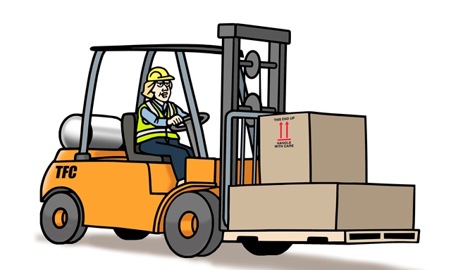
How Long Does It Take for a Forklift Course to Complete? – It is hard to tell how long does it take for a forklift course to complete as there are many other factors involved.
If the trainee has some knowledge and experience may need less comprehensive course than those without experience. It would take more time for them to complete the course.
Another factor that affects the length of the training is the type, of course, you will take. If the trainee knows how to operate a counterbalance forklift and he is assigned to operate another type, he may need to retake a course specifically for that type.
The refresher course should be part of the company’s safety procedure. Refresher courses may take lesser time to complete than basic training which stretches for a day.
How long does it take to get forklift certified
Forklift Operator Training
To protect the welfare of the operators and ensure that they received appropriate and enough skills, the training should consist of three components:
The classroom lectures,
actual hands-on driving and
performance evaluation.
The classroom lecture shall comprise of interactive video, PowerPoint presentation, OSHA regulations, and the operator must pass the written test after the classroom discussion. During the practical demonstration, the operator should accomplish the sets of instructions the trainer assigned them to do.
The company or training school shall certify that each operator has given such training.
When a new type of forklift is brought to the workplace, it is compulsory for the operator to take the training for this type of machine.
It is inevitable for change of workplace, this is true when you’re working in construction, port, and warehousing company. Any change of environment should push employers to provide training for the operators.
Operators who have performed poorly during an assessment should be retrained.
If an operator has already received training in certain topics or portion of the training course, supplemental training in that area is not required.
How Long does it Take to get Forklift Certified?
How can I get my forklift license online?
The 1-2 hour online forklift evaluation training course will allow you to become a certified forklift operator in compliance with OSHA laws.
Is online forklift certification legitimate?
Absolutely! All of the online training and certification programs include the very latest OSHA requirements and other training information.
Forklift safety is of the utmost importance, and driving a forklift improperly presents various risks to both yourself and others, as well as your surroundings and the things you’re lifting.
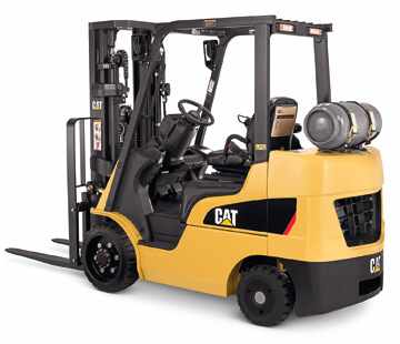
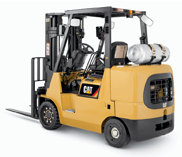
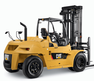
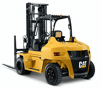
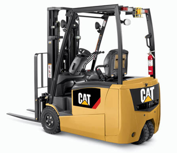
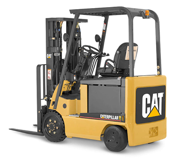
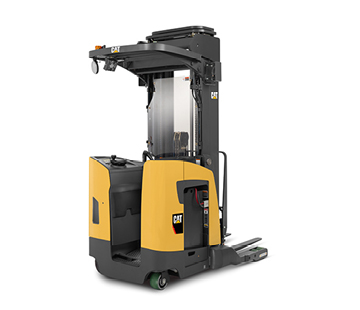
Caterpillar Forklift specs: Caterpillar Cat® forklifts solve the problems presented by material handling applications. Choose from a line of forklifts backed by the industry leader in customer service and support.
Caterpillar Forklift Specs
Caterpillar forklift
Caterpillar Forklift specs: Caterpillar Cat® forklifts solve the problems presented by material handling applications.
CAT forklift or forklift: Innovative materials handling solutions
That’s why Cat forklifts provide equipment backed by the industry leader in customer service and support.
Built to function, Cat forklifts are shipped every day because they provide models to meet the demand for reliable material handling equipment and a level of service equal to that of our quality products.
Caterpillar forklift models
With load capacities ranging from 2,500 to 36,000 lbs., The Cat lift line consists of pneumatic wheel loaders with internal combustion engines and pneumatic wheel lifts with electric counterweights.
With a focus on quality, reliability, and customer service, Cat forklifts offer the material handling solutions you expect.
Forklift models:
Of combustion
Electric
Retractile
Drag
Operator on board
Order picker
Caterpillar forklift specifications
With spacious compartments and low operating effort, Cat forklifts set the standard for the latest forklift experience.
Manufactured in Houston, Texas, according to ISO 9001: 2000 quality standards and ISO 14001: 2004 environmental system standards, Cat hoists are designed to increase the productivity of any material handling operation.
Forklift Datasheet
Reliability of the Caterpillar Forklift: Industry-leading features such as “fingertip” controls, the Presence Detection System (PDS), informational displays, and high-strength mast designs and the fork carriage are just some of the reasons why Cat forklifts are still being shipped.
CAT forklifts specifications
CAT fork crane: Minimize downtime, increase productivity and experience the performance without limitations of a Cat forklift.
With the use of heavy forklifts in several shifts, customers can request products that meet the highest standards.
To meet your expectations, Cat lift trucks provide products that require little maintenance and offer extended service intervals.
New forklift price
Customer Service: By providing customers with planned full maintenance and by reducing downtime, Cat lift trucks are designed to assist you in your final result.
Let the industry-leading dealer network provide you with the best factory support programs and pricing and unparalleled dealer capabilities.
New forklift caterpillar
Caterpillar forklift customers: Cat forklifts place the customer’s needs first with the comprehensive backup programs of today’s industry.
Each new forklift has a warranty of one year or 2,000 hours, a warranty for two years or 4,000 hours of the power train and a guarantee of immediate parts or warranty without the cost of the parts, which ensures the delivery of parts the next business day in the location of your local distributor or they are free.
Forklift batteries
The most common forklift battery is one that contains lead-acid and includes a lead plate (negative electrode), an electrolyte solution of sulfuric acid, and another lead peroxide plate (positive electrode). Every time you operate a forklift or other motorized vehicle, inspect it to verify that it is working properly.
It is worth mentioning that the best way to preserve the batteries, whatever they may be, is through a daily control of their condition and a good use of them, but to do this, make a good maintenance of forklift batteries, you need to incorporate a vital information series otherwise you can not do it efficiently.
First of all, keep in mind that a battery and a battery are electrochemical devices that have the capacity to store energy in a completely chemical way.
Once the battery is fully or partially charged, this chemical energy is transformed into electrical energy that is subsequently transmitted via a circuit to a motor that transforms it once again, this time into mechanical energy that enables the movement of the vehicle.
Forklift handling
Set a speed limit:
Driving too fast is one of the most common causes for a forklift to tip over.
Communicate the speed limit to your staff and make sure it is posted throughout the worksite.
Many forklifts do not have speedometers, but some may be equipped with controllers that prevent the vehicle from exceeding a certain speed.
Workers must know what equipment is installed on the forklift and whatnot, and act accordingly to maintain a safe speed. If the floor is slippery or if there are pedestrians or other nearby vehicles, you must drive below the speed limit.
Forklift operator
All forklift operators must have employment authorization and be certified on how to operate the vehicle safely.
The training should consist of a combination of formal instruction such as lectures and discussions, hands-on training that includes a hands-on demonstration and evaluation of the operator’s performance in the workplace.
The refresher training must be done at least annually or with any incident.
No one under the age of 18 should operate a forklift.
Safe forklift handling
Plan the route and anticipate any turns along the route.
Be careful and keep the speed low when making turns.
If a turn is taken too fast or too tight, the risk of a rollover increases.
Never turn on a slope, since the forklift can overturn even on a small hill.
Never turn with the forks in an elevated position.
Drive the loaded forklifts forward when going up a ramp and in reverse when going down.
Do not perform any acrobatics.
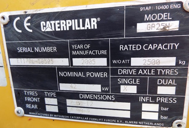
Caterpillar forklift serial number lookup
Where Do I Find My Caterpillar Forklift’s Serial Number?
The most direct way to find your Caterpillar forklift’s serial number is to check the forklift’s nameplate (also called a data tag).
This helpful little label includes lots of various details about your lift–its model, its weight, its lifting capacity, and more.
Most importantly, the nameplate also displays the forklift’s serial number.
On a Caterpillar forklift, is often found near the dashboard
Checking the nameplate is the quickest and easiest method of discerning the serial number of your forklift. But what if the nameplate wears down or has fallen off? You’re not out of luck just yet. Sometimes, a Caterpillar forklift’s serial number can be found physically stamped on its frame.
Caterpillar Forklift specs
Forklifts pictures
Of combustion
Electric
Retractile
Drag
Operator on board
Order picker
de combustionde combustionde combustionde combustion electricelectricelectricretractible
Caterpillar Forklift specs
How much does a CAT forklift cost?
How much does a CAT forklift cost?
According to one vendor, an internal combustion forklift with a 5,000 lb. capacity and pneumatic tires costs around $20,000,the same vehicle with air-cushion tires costs around $18,000, and a comparable electric forklift with battery and charger costs approximately $25,000.
What are forklifts used for?
A forklift (also called lift truck, jitney, fork truck, fork hoist, and forklift truck) is a powered industrial truck used to lift and move materials over short distances.
What is the average salary of a forklift operator?
The average pay for a Forklift Operator is $13.66 per hour. in the U.S.
Who makes Cat forklifts?
Mitsubishi Caterpillar Forklift America Inc. (“MCFA”), headquartered in Houston, Texas is a manufacturer and distributor of material handling equipment and parts under the Mitsubishi Forklift Trucks, Cat Lift Trucks, and Jungheinrich brand names.
Forklift Brands and models: Which forklift brand is best? Top brands in the world: Caterpillar, Toyota, Volvo, Hyundai, forklift brands and models, top 10 forklift brands.
Forklifts are extremely useful workplace vehicles, as long as they are used safely and appropriately by operators who are appropriately trained and competent to use them.
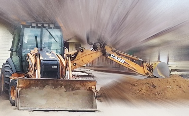
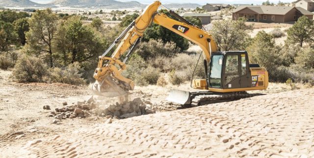
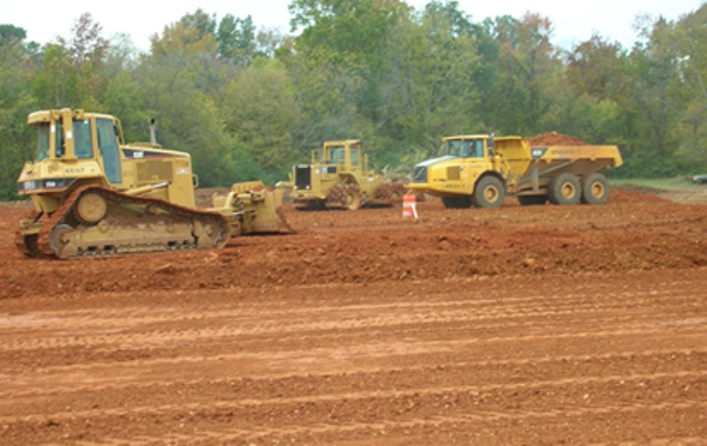
Excavating Contractors: Well before a building or any structure is erected, excavating contractors is hard at work. But what is the role of an excavating contractor, exactly? Well, they perform a variety of tasks aimed at readying the ground before construction begins.
Excavating Contractors
Earthwork contractor
If you have ever wondered why you needed to hire a professional excavating service for your project, this article is for you as we will be detailing the specific tasks that are carried out by them, including
Local excavating contractors: what is site clearing in construction?
Clearing the construction site: Prior to construction, an excavating service will be taking steps to have existing structures knocked down and old foundations dug up. Also, any trees on the property will have to be cut down, and the roots will have to be removed. And finally, the ground will have to be made level.
Digging foundations
Local excavating contractors: digging footings for single storey extension
Digging the foundation: After reviewing the building plans, an excavating service will begin excavating the ground, allowing for foundation forms to be put in place. It should be noted that this process also includes ensuring that the foundation is poured in accordance with the building plans.
Excavating Contractors
Excavation companies
An excavating service is critical to any build and worth the investment. They can help safeguard you from financial losses and also streamline the completion of your project.
Excavating contractors services:
Excavation services
The excavating service will also supervise the crew tasked with digging the trenches for the foundation, ensuring that they follow the building plans to the letter. This important because once the foundation is poured the work will have to pass inspection before construction can begin.
Excavation equipment rental
Heavy equipment is essential as an excavating service, and as such, they will be responsible for supervising a team of heavy equipment operators who will be clearing the site and prepping the foundation.
Excavating Contractors
Residential excavation contractors
Residencial excavating contractors services:
Building and refurbishment
Building and refurbishing driveways: Needless to say, a driveway/parking lot is critical to any new construction project, and this part of the job must be done before construction gets underway.
An excavating service will work to prepare the grounds for this part of the build. Once the foundation is in place for the driveway/parking lot, an excavating service will then add the finishing touches in the form of paving stone, tarmac, or other materials.
Septic system installation
Septic installation: If a septic system will be part of your build, it’s a good idea to hire an excavating service. After all, installing a septic system requires special licenses and training, which is precisely what an excavating service provides to their clients.
Also, they ensure that all installations are done correctly. When it comes to installing a septic system, this is not an area to skimp out on. It’s important to get the job done right the first time to avoid the high cost of a failed system later.
Excavating Contractors
Grading and excavating contractor
What other ways are grading and excavating used for?
Along with leveling and preparing the land for foundation pouring grading and excavating are used for other purposes as well:
Site Clearing
House Pads
Land Leveling
Ditches
Basement Excavation
Foundation Excavation
Erosion Control
Dirt & Rock Excavation
Driveway & Road Installation
What factors determine the costs of having an area graded or excavated?
There are many factors that go into determining the cost of grading or an excavating project. You need considers these factors:
Size of the Property
The Density of the Land
Erosion Control
Quality of the Soil
Heavy Equipment that Will be Required
Existing Site Properties Fill
Dirt, Slope, Cut and Fill
Existing Rocks, Trees, and Bushes on the Property
If you are beginning a project whether it is commercial or residential having a quality contractor is essential for success. Every building project begins with clearing the land and preparing it before a foundation can even be poured. If this is not done correctly it can result in drainage issues, erosion, and more. Why not start with a professional? Beginning a project correctly with those who have knowledge and expertise will save you money in the long run.
Excavating Contractors
Homeowners insurance protects
Homeowners insurance gives you both property and liability protection
Liability protection: Because they follow safety guidelines outlined by OSHA (Occupational and Safety Hazard Association), an excavating service will always place an emphasis on safety.
They also carry liability insurance in the event that something should go wrong. Lastly, they make it a point to follow all code and regulatory requirements mandated by the municipalities where the job is being executed.
Excavating Contractors
Excavation book
excavating contractors books in amazon.com
Moving The Earth: The Workbook of Excavation
The definitive guide to earthmoving and machines – fully updated.
“The most comprehensive source of basic excavation information available.”
Construction Methods & Equipment
Completely revised throughout for the latest methods, equipment, and regulations, Moving the Earth, is the industry-standard source of practical expertise for the excavation and construction industries. This all-inclusive workbook covers every aspect of site preparation and management, and details every machine and vehicle needed to perform each task.
This edition includes new information on international developments in earthwork construction, updated OSHA excavation safety standards, and both SI and U.S. customary units. Detailed and comprehensive, this practical, on-the-job guide is as indispensable as your hard hat.
“The down-in-the-dirt standard work for the excavation industry.”
Military Engineer
Moving the Earth: The Workbook of Excavation
This groundbreaking new edition of the classic guide to heavy excavation projects and equipment provides the latest, most comprehensive guidance in the field. From site preparation to blasting and tunneling, pneumatic drills to the largest power shovels, it covers every step of every kind of excavating project and all the practical aspects of using the machines and vehicles involved.
This first major revision in 20 years features insight into the latest general construction technology and methods, updated material on the costs and management of excavation projects, and an abundance of new clarifying photos. As easy to read as it is expansive in scope, the new edition is indispensable “heavy equipment” for every professional involved in excavation and construction.
Excavating contractors
Why Do You Need Excavating Contractors?
Excavation contractors own a number of responsibilities than just moving around the dirt. They prepare the site, perform grading and trenching as well as other tasks associated with soil. Therefore, you must know why you need an excavating contractor.
Just after the survey of the land, lot or a typical residential area, the excavation contractor comes to conduct the compaction tests of the soil.
This is to ensure that the soil is removed to the depth, so a new foundation could be established. The contractor does the testing with equipment if required. To match the grading done in surveying, the contractor ensures that the excavation requirements are met. It is critical as the grade level is precise.
Excavation contractor starts to work on the new foundations; meanwhile, the stem wall and footers are poured by the foundation contractor. Being the sub-contractor of the large project, excavation contractors are business owners.
They work under the general contractor, who manages their schedule, bids, and payments. However, you can contact the excavation contractors for your house works; like digging the pool. This only includes a specific job and not the entire project.
What are excavating contractors?
What is an excavating contractor?
An excavating contractor is someone who can operate a heavy piece of construction equipment called a grader and hold a CDL license. A grader is a heavy piece of equipment that can smooth and flatten the surface of the soil for roads, foundations of homes, and other building projects.
What is grading and excavating?
To further understand what a grading contractor is you need to understand more about the process of grading and excavating. Grading and excavating is the process of preparing the land for building. This can be done by smoothing out the soil, flattening an area, building an area up, or sloping it to a certain degree that is needed.
What is grading in construction?
Grading is the leveling of a given area in preparation for pouring foundations of homes or businesses. Grading is not a DIY project that just anyone can undertake themselves. That is why legally to run a piece of the heavy equipment you are required to have a special CDL license. Professional contractors will also have the expertise to determine what angle your slope will need to be when leveling so water will run away from the buildings you are constructing. However, grading cannot happen until your building site has been cleared of any obstructions.
What is excavating in construction?
In contrast to grading excavating is about digging up and moving earth with equipment. After trees and undergrowth have been cut down and removed from a property the area may still have obstructions that need to be removed. These can be large stumps, boulders, other large rocks, or any other organic material that is in the way.
The backhoe is the main tool of the backhoe loader. It’s used to dig up hard, compact material, usually earth, or to lift heavy loads, such as a sewer box.
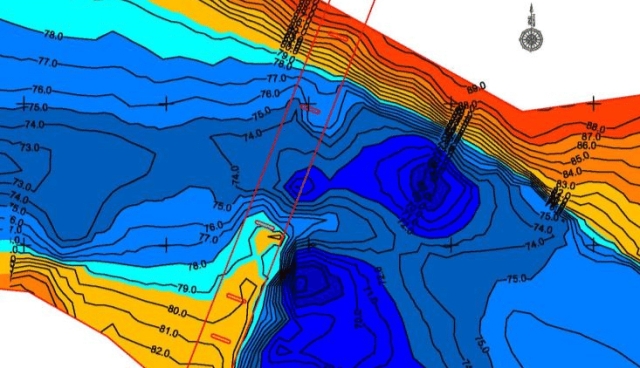
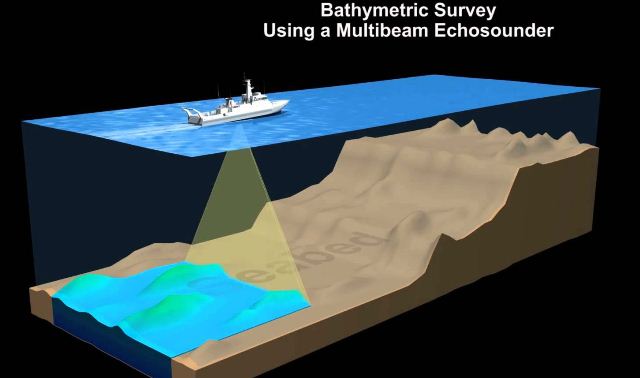
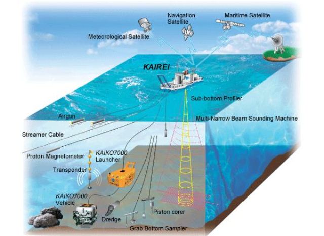
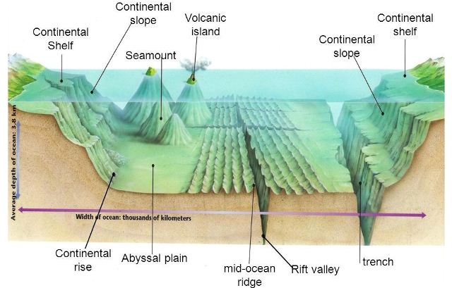
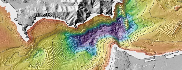
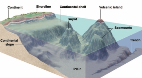
Bathymetric Survey equipment: Bathymetry is the study of the underwater depth of the lake and ocean floors. In the bathymetric survey, charts are produced to support the safety of surface or sub-surface navigations which usually show seafloor relief or terrain as contour lines (depth contours), and such a chart provides surface navigational information. The survey sets for best description of the submarine topographical features that may include sound velocity and slope corrections that are more accurate but eliminate the safety bias.
Bathymetric Survey Equipment
Bathymetric and hydrographic survey
Bathymetric survey equipment are important for many purposes; such include sedimentation purposes to check for accretion or erosion, pre and post dredging bathymetry, that is to determine the existing status of the water body or to ascertain the dredged volume. It can also be done prior to pipeline and cable (laying) positioning, fishing, and other geophysical exploration exercises.
Updating of bathymetric chart is a daunting task and cannot be overpassed due to its importance in estimating or determining temporal changes in an ocean floor which in effect; provides accurate information for public usage, in terms of planning, engineering design, construction, operation, maintenance, and regulation of navigation, flood control, river engineering, charting, and coastal engineering projects.
Resurvey policy especially that of bathymetry gives bounds for the reliability of identified sea erosion and accretion areas, determination of sediment transport pathways, the magnitude of sediment transport estimates, and the validity of sediment budget estimates.
Bathymetric Survey Equipment
Bathymetric survey cost
Comparison of digital bathymetric data for the same region but different time periods provides a method for estimating or calculating the net movement of sediment into (accretion) and out of (erosion) a study area. Producing a bathymetric chart; tidal observation and reduction is a must to reduce the sounding depth to chart datum.
Tidal observation is conducted prior to and concurrently with sounding operations period and can be done on the established gauge or temporarily on any selected position where the water level hardly goes below the zero reading of the measuring device (Temporary gauge).
The reduction applicable to sounding depth is done based on the rise and fall differential subtraction for gauge data using an instantaneous timing interval for each sounding point. Further processes have to do with spike removal, HYPACK matrix generation and possibly preparation of schema for ideal data structuring; then the production of a bathymetric chart.
A proper environmental impact assessment needs to be done in order to assess the level of impact caused by man and nature, especially as it concerns coastal waters.
The bathymetric survey equipment is important for the production of the up-to-date bathymetric chart, due to mining exercises opined by local miners and licensed dredging companies.
In the absence of mining exercise, there is a need to investigate and account for sediment deposit or eroded, so that proper planning responses can be implemented. It is, therefore, necessary to update the bathymetric chart covering, which would be compared with the earlier bathymetric survey equipment; for investigating sediments (Accretion and Erosion) and dredged region area.
Bathymetric Survey equipment
Marine protected areas
Bathymetry surveys are the first step for every conservation effort on Marine Protected Areas (MPAs). Maps depicting depth and bottom geomorphology are used to generate hillsides, that later become base maps for other themes, such as fish distribution, bottom types, and water quality.
Bathymetry map availability is limited or non-existent at the scales that are necessary for MPA management plans. Survey costs by traditional-sounding methods or new technologies, such as LIDAR, are prohibitive for most MPA budgets.
Remote Sensing bathymetry is yet unreliable, except for crystal clear waters. A low-cost technique, based on commercially available GPS-echosounder units was applied to obtain detailed bathymetry of two MPAs in coastal.
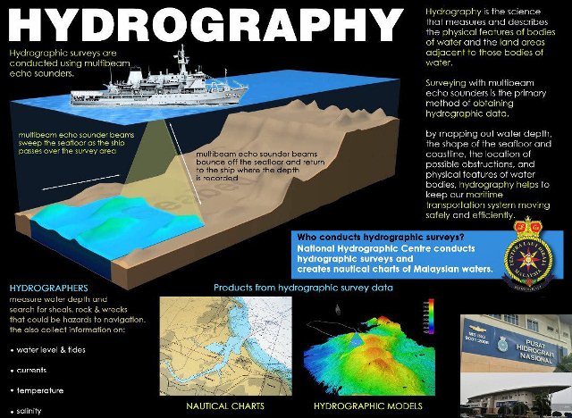
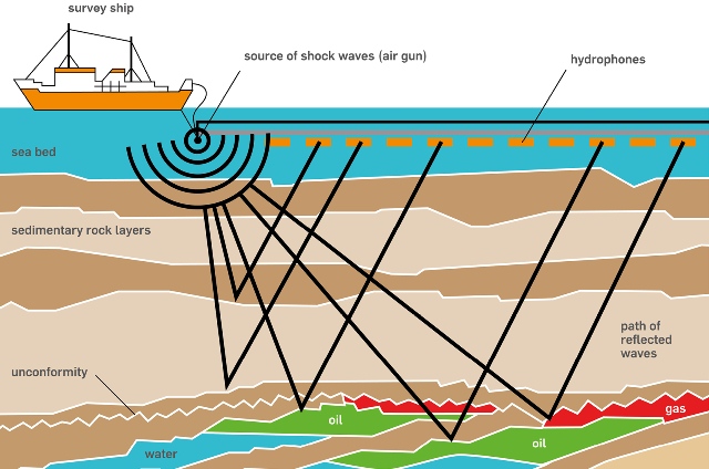
Hydrographic survey
Hydrographic Charts as used by seafarers are based on data accumulated over years of professional surveying operations. Standard hydrographic charts either in paper form or as ENC are available for most areas of the world and are quite inexpensive thanks to two factors: government-subsidized hydrographic surveys and a large number of charts printed for numerous users.
Dedicated charts, as produced for the offshore oil & gas industry, coastal engineering, cable-laying operations, etc. cost a similar amount to produce but are much more expensive to buy due to the limited number of users and additional requirements. For these charts, navigational (safe) depth is insufficient; detailed sea bottom morphology is required.
Bathymetric Survey Equipment
Hydrographic services
In both cases, the basis for the hydrographic charts, bathymetric survey equipment operations, have been and still are a rather costly affair. In the old days they were costly because the instruments used, lead line, sextant and the like, provided only a sounding every now and then whilst ship-time ticked by.
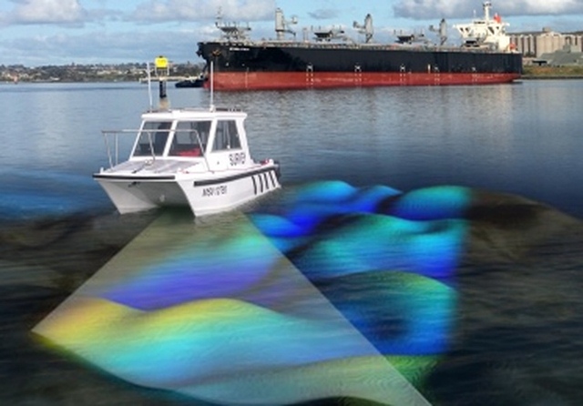
Nowadays bathymetric information is typically gathered from dedicated survey vessels using single or multi-beam echo sounding systems. The prime cost factor in ship-borne surveys is the time and thus the expense involved in conducting the survey and in data post-processing. Delays due to factors such as weather-related downtime, logistics, red tape and instrument breakdown can cause operational costs to go through the roof.
Bathymetric survey equipment cost
The execution of a cost-effective hydrographic survey necessitates the use of a package of three:
Well trained personnel,
Accurate, reliable instrumentation and
A suitable survey vessel.
Bathymetric Survey Equipment: How can we save on these?
Survey personnel has, historically, not been in the top regions of offshore personnel salary scales. There are signs that this is changing gradually (which is necessary to keep enough people in our business!) and the only way to reduce costs here is to deploy personnel on the job.
Thanks to advanced survey systems and computer equipment, this is a possibility, to a certain degree. The other way would be to work longer hours to keep equipment and ship operational for longer periods, but this is done already: for most offshore survey operations, a 24hrs working day is no exception.
The other possibility to optimize survey operations is to deploy more advanced, more productive survey systems. Positioning-wise, we are “on dry ground” already: The horizontal positioning world has been turned upside down in the past 25 years by the implementation of GPS and DGPS.
DGPS survey
Although freely available DGPS has a stated horizontal accuracy of +/-10 meters (95 percent), many mariners are claiming 3-meter or better accuracy with this system. With selective availability set to zero, the most basic GPS receiver in a non-differential mode may offer 10-15 meter horizontal accuracy.
Some sophisticated survey receivers now advertise sub-meter accuracy and with (long-range) RTK systems, the cm accuracy levels can be reached for both horizontal accuracy and vertical referencing.
Echo sounder for bathymetric survey
Bathymetric Survey Equipment: What else can we ask for?
For bathymetric measurements, great improvements have been made the last two decennia. In the past, survey lines were sailed and only the depth directly under the vessel was measured using a single beam echo sounder.
Then, multi-transducer systems were developed whereby an array of transducers was fitted on a pole, fitted perpendicularly onto the vessel, giving a swath width of the length of the pole. The system is still very useful for very shallow water.
Nowadays, we have multi-beam, providing fan-shaped coverage of the seafloor similar to side-scan sonar, but the output data is in the form of depths rather than images.
Bathymetric Survey Equipment
Multibeam echo sounder
The multi-beam system measures and records the time for the acoustic signal to travel from the transducer to the seafloor and back. For bathymetric purposes, multi-beam transducers are generally attached to a vessel, rather than being towed like a side scan. Therefore, the coverage area on the seafloor is dependent on the depth of the water, typically two to four times the water depth.
The production rate of multi-beam is many times that of a single beam and for an increasing number of (larger) surveys, it became a price decreasing survey tool. Post-processing of the results of this system has still a considerable price impact due to the vast amount of data that is generated, but new processing packages, such as Triton Images’ multi-beam software, are quickly helping to overcome this.
Bathymetric Survey Equipment
Survey platform
The third, but a major factor of costs is the survey platform. Indeed, it may be well possible to select suitable personnel and equipment for a reasonable price, but the platform on which these have to be placed to perform the work, a ship, is still the major cost-component of bathymetric survey equipment.
Improved ship design, less ship’s crew, higher survey speed, less fuel consumption and on-board data processing and charting may increase the vessel’s cost-effectiveness, but ships remain expensive.
Bathymetric LIDAR system
For certain applications such as surveys in relatively shallow, clean water, Lidar solutions with combined RTK-DGPS / Inertial systems will provide alternatives.
The high speed and enormous amount of data generated enable covering large areas in short survey time. Lightweight Lidar systems (Hawkeye 2) are being developed and smaller airplanes or helicopters can be deployed from remote airfields all over the world to execute such surveys.
For large projects, whereby a multitude of sensors have to be deployed over prolonged periods of time, Zeppelin-type aircraft may become a cost-saving platform: with payloads of over 35 tonnes, the endurance of several weeks in the air and an airspeed of 150 knots, large areas can be surveyed at reasonably low cost.
Bathymetric Survey Equipment
Survey vessel
Another possible cost-saving alternative for a survey vessel (or in combination with it) is the AUV. This sensor platform can, in certain cases, be deployed from the shore and execute surveys in a stable (underwater) mode at high speed without on-board personnel.
A study of the broader scope of AUV mission applications for the U.S. Navy was recently completed by a US Navy R&D team. The study, which looks ahead 50 years, provides a roadmap to use in integrating AUV’s into the battlespace of the future.
One of the most significant recommendations in the AUV Master Plan was that many missions could be completed using multiple, inexpensive, small AUV’s rather than fewer large and expensive ones.
Nowadays, several research institutes and AUV manufacturers, such as Hafmynd Gavia are working on the development of the deployment of multiple AUV’s from shore or ship. Various operational procedures and survey modes (lawnmower-pattern, Master AUV – multiple slave configuration, etc.), navigation control, testing facilitation, are under development.
Although survey systems will develop even further, personnel costs can be reduced by deploying less personnel and AUV’s, Zeppelins, Survey Vessels, and possible future creations may form a pool of suitable hydrographic sensor/personnel platforms from which the most cost-effective solution can be chosen, it will remain a difficult task to explain why hydrographic surveys are “so expensive”.
Bathymetric Survey Equipment
Bathymetric study
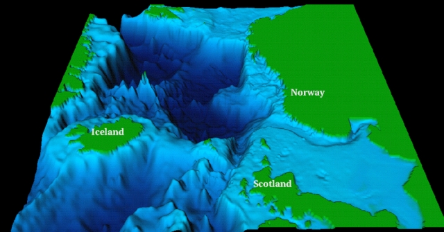
The term “bathymetry” originally referred to the ocean’s depth relative to sea level, although it has come to mean “submarine topography,” or the depths and shapes of underwater terrain.
In the same way that topographic maps represent the three-dimensional features (or relief) of overland terrain, bathymetric maps illustrate the land that lies underwater. Variations in sea-floor relief may be depicted by color and contour lines called depth contours or isobaths.
Bathymetry is the foundation of the science of hydrography, which measures the physical features of a water body. Hydrography includes not only bathymetry, but also the shape and features of the shoreline; the characteristics of tides, currents, and waves; and the physical and chemical properties of the water itself.
Bathymetric Survey Equipment
What is meant by the bathymetric survey?
Bathymetry is the study of the underwater depth of lake or ocean floors. In other words, bathymetry is the underwater equivalent to hypsometry or topography.
What is the difference between hydrographic and bathymetric survey?
Bathymetric or Hydrographic are both terms referring to submarine topography and are sometimes used interchangeably. The results from a hydrographic survey are normally plotted to produce a bathymetric contour map, which is a plan of the depth of the sea bed arranged in such a manner as to show lines of equal depth from the coastline. In a hydrographic survey, the actual measurement of the water depth is the easy part.
What is meant by the hydrographic survey?
Hydrographic survey is the science of measurement and description of features that affect maritime navigation, marine construction, dredging, offshore oil exploration/offshore oil drilling and related activities. Hydrography is collected under rules which vary depending on the acceptance authority.
How is bathymetry data collected?
Acoustic Bathymetry Survey uses sonar (sound navigation and ranging) systems to collect depth information, using simple physics. Basically, a transducer emits a sound wave directly to the water’s floor and records the time for the sound wave to be reflected back after it strikes the bottom.
Why is bathymetry important?
The variation in relief constitutes the morphology of the ocean floor. Charting of the ocean is very important for many reasons: it affects circulation, a potential site for living and non-living resources, submarine navigation, geophysical exploration, etc. In brief, bathymetry is the seafloor-relief.
What is LIDAR and how does it work?
LiDAR is a remote sensing technology that uses the pulse from a laser to collect measurements which can then be used to create 3D models and maps of objects and environments. LiDAR works in a similar way to Radar and Sonar yet uses light waves from a laser, instead of radio or sound waves.
Topographic maps offer detailed information on a particular area and are used for several types of activities such as emergency preparedness, urban planning, resource development, and surveying to camping, canoeing, adventure racing, hunting, and fishing.
Topographic maps of the seafloor. Detailed depth contours provide the size, shape, and distribution of underwater features. The map serves as a tool for performing scientific, engineering, marine geophysical and environmental studies, that are required in the development of energy and marine resources.
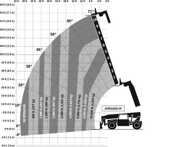
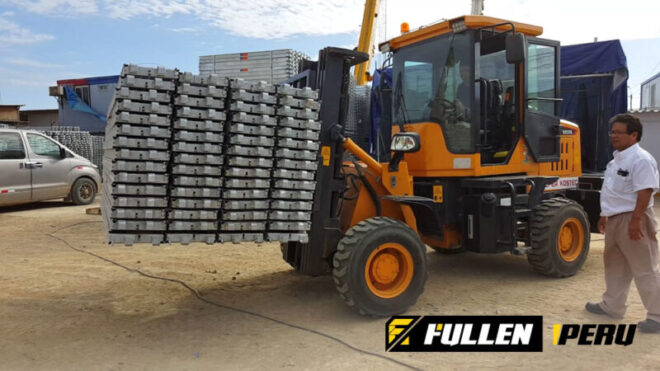
Forklift Lifting Capacity: limits and driving of loading and unloading, operator and handling in workshop, plant, counterweight, operator, transport.
What useful load can forklifts transport?
What minimum requirements are necessary for a forklift?
And for the industry?
Forklifts are one of the main solutions to transport both objects and loading pallets, saving different stories high.
One of the main characteristics of this type of elevator is undoubtedly its great versatility and is that both those that are intended for cargo transport, such as those used in shops or industries to transport objects of different volumes and weights are achieved according to the needs of the client.
In this way, we can find from small lifts to large lifts with enough dimensions to transport even large volumes of cargo.
Forklift Lifting Capacity
Forklift weight capacity
Forklifts have different capacity ranges for good reasons. The problem is that forklift operators sometimes mistakenly judge the load capacity of the machine.
They have seen some forklifts handle very heavy loads, so they generalize that capacity to any forklift. However, this can trigger a catastrophe.
The greatest danger to the safety of operators is the same characteristic that makes forklifts so popular.
Its ability to lift and transport almost any type of load, within its weight capacities.
But the problem is in the instability of the forklift once it has a very heavy load on board.
When the load exceeds the capacity of the forklift, the machine becomes quite unstable, with a variable center of gravity that, unless handled with exceptional care, can cause it to overturn and begin the problems.
Other dangerous factors are the incorrect use of restrictions to secure the load and a sudden change in speed or movement that causes the load to move, causing the forklift to lose its balance.
Of course, there are other reasons for the thousands of accidents that occur each year, but almost all forklift accidents, minor or fatal, could have been avoided if the driver had received training and had respected the safety rules understanding the relationship between the counterweight and the load weight
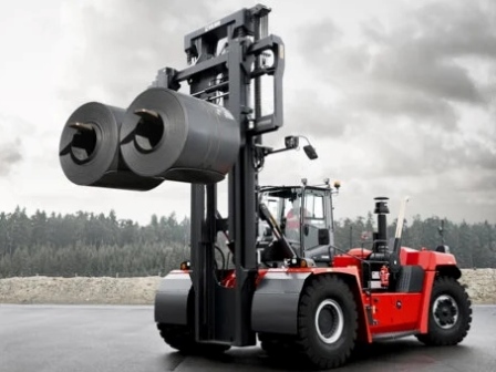
Forklift Lifting Capacity
Forklift counterweight
The own weight of the forklift serves as a counterbalance to balance the different loads.
During the use of the forklift, the weight of the load multiplied by the distance separating it from the central support (called the inflection point) must be equal to or less than the weight of the forklift (which will act as a counterweight).
This will prevent excessive balancing, which could result in the fall of the load or the entire forklift.
Speaking more simply, the loads that a forklift transport must have less weight than the forklift itself.
The falls of loads with possible breakage of materials or injuries of the operators are the most common effect of ignorance of the load capacity of a forklift. This, of course, can be avoided with constant training for operators and employers.
You should not make the mistake of simply giving your operators the keys to the equipment and pointing out the work.
Forklift Lifting Capacity
Forklift load capacity
How do I calculate the capacity of my forklift?
You can do a little research online looking for the model of our forklift.
In the specifications of the forklift, you will surely find its maximum load capacity, and if not, you will find its total weight.
Multiplies the weight of the load by the distance that separates it from the central support.
Always make sure that it is less than the total weight of the forklift.
This ensures you have no problems with the load capacity of it.
Forklift safety
In all places where forklifts are used, they must exist
Speed limits
proper ground evaluation
maintenance procedures to ensure safety
guidelines on how to upload and download
rules on how to transport materials correctly.
If all these precautions are taken into account, the chances of accidents at work and waste of materials will be minimized.
Never carry a load that requires another employee to physically stabilize the load while moving the forklift.
Never carry a load that exceeds the maximum capacity of the forklift.
One sign of a heavy load is that the rear wheels rise when the load begins to rise.
In these cases, lower the load immediately and change the lifting equipment or reduce the weight of the load.
To maximize stability, the load must be hooked and centered on the forklift nails.
The load should be supported against the back or vertical part of the nails.
In addition, the length of the nails should always be of the length of the load, or greater.
To prevent the load from tilting forward, the forklift mast must be tilted backward.
If necessary, separate the nails before lifting the load.
As a general rule, the wider, the better.
Forklift operator training
Tests and training to check the knowledge of the operator
Trained operators must be able to demonstrate their ability, and their employer must test each operator with training.
In this way, unsafe work practices are avoided.
Employers must organize, during or after work hours, adequate training for anyone who is expected to operate or work with a forklift.
Initial training should include:
Basic training so that the operator understands all the skills and knowledge he needs to operate the forklift safely.
Specific job training adapted to the particular needs of the company, safety procedures and the type of work to be carried out.
Familiarization training that must be completed at work and supervised to familiarize the apprentice with the forklift, the design of the site, among other aspects.
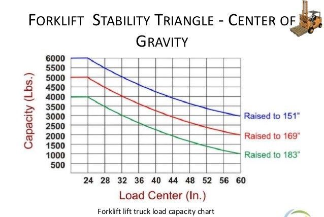
First, you have to consider the vertical and horizontal load center of the load that is being lifted, which essentially boils down to the load’s size and weight distribution. The longer, taller, and wider a load gets, the more it is going to affect a forklift’s center of gravity.
Since the load center also depends on the load’s weight distribution, an unevenly distributed load can also reduce the overall lifting capacity of the forklift.
Second, you have to consider the truck’s capabilities for lift, tilt, and load manipulation. Forklifts are plated as standard for the worst-case scenario, which includes all of these factors.
The ability to move the load further away from the forklift’s center of gravity by lifting, tilting, or performing a function as a side shift can all affect a forklift’s maximum capacity.
Forklift wheels
Speaking of attachments, there are more factors than just load manipulation that can affect capacity. An attachment’s effective thickness tells you how much further the load is pushed out from the truck’s fork face due to the attachment’s size. Its weight also plays a significant role as that increased weight out on the carriage reduces the load weight that the truck is capable of supporting.
Different tire types and tread widths also play a significant role. A cushion tire versus a solid or air-filled pneumatic tire, for example, can have an effect on capacity.
Wide tread and dual tire configurations can also increase a truck’s overall capacity due to the wider stance increasing the size of the forklift’s stability triangle.
Battery weight on an electric truck can also have an impact, which is one reason why using a battery that meets the truck’s minimum battery weight requirements is crucial to safe operation.
Forklift lifting capacity calculator
One thing to also keep in mind is that the forks, each attachment, mast, and carriage all have their own individual rated capacities. The capacity listed on your data plate cannot exceed the maximum capacity of any load-bearing component.
For example, if you have a 10,000 lb. capacity forklift with an attachment that is only capable of handling 5,000 lbs., your maximum rated capacity for the combination of these two is 5,000 lbs., which is what will be listed on your data plate.
It is important to remember that both ANSI and OSHA require data plates for each attachment and written approval from the forklift manufacturer for any modifications or alterations that may affect the capacity, stability, or safe operation of the forklift.
There are two different ways for a manufacturer to calculate capacity.
The first is a tilt table test, which requires a forklift to be chained down to a tilt table and tested per the requirements.
The second is for manufacturers to calculate the forklift’s capacity based on factors like the ones mentioned above.
Tested capacities are typically higher than calculated ones due to the conservative nature of the calculation, but this is not always the case.
Forklift data plate
he factors listed above are but a few of the primary factors that will be used to calculate a forklift’s rated capacity.
Ultimately, it’s best for you to work with your local authorized dealer when it comes to properly configure your forklift for your application and load handling needs.
This is especially important during the purchasing process, but also in regard to any modifications, you may make to your forklift after receiving it, including any attachments that you plan to use on the forklift or those acquired later on.
For more information regarding forklift modifications and best practices, be sure to read this piece on forklift field modifications.
Forklift questions
What is the maximum weight a forklift can lift?
This forklift can carry 4,000 pounds at a 24 inches load center, but only 2,666 pounds at a 36 inches load center. Requirements and Recommended Practices: Estimate the safe load capacity with oversized loads.
How do you work out the load capacity of a forklift?
It is easily calculated by measuring the load to be carried, and dividing by two (providing the load is evenly distributed, and positioned to butt up to the forklift backrest). You will often see a forklift truck’s nominal capacity quoted in a form such as 2,000kg @ 500mm load center.
A brand new, standard capacity electric warehouse forklift might cost approximately $15,000-$25,000 or more in addition to around $2,500 to $5,000 for a battery and charger. A comparable internal combustion forklift costs around $15,000-$30,000 and up.
What is the useful life of a forklift?
As a general rule, forklifts have an economic life of approximately 10,000 to 12,000 hours. Again, this varies based on maintenance practices, operating conditions and the type of equipment used. In order to run an efficient and productive operation, the timely replacement of machinery is crucial.
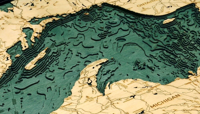
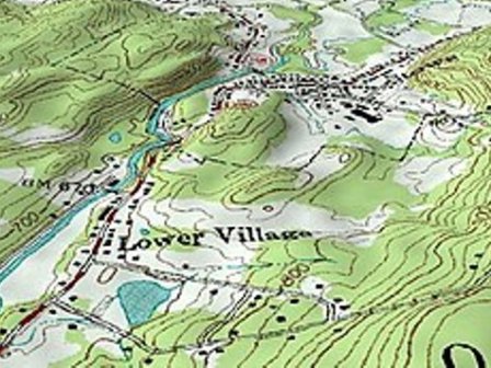
A map is a representation of the Earth or part of it. The distinctive characteristic of a topographic map is that the shape of the Earth’s surface is shown by contour lines. Contours are imaginary lines that join points of equal elevation on the surface of the land above or below a reference surface, such as mean sea level. Contours make it possible to measure the height of mountains, depths of the ocean bottom, and steepness of slopes.
A topographic map shows more than contours. The map includes symbols that represent such features as streets, buildings, streams, and vegetation.
These symbols are constantly refined to better relate to the features they represent, improve the appearance or readability of the map, or reduce production cost. Consequently, within the same series, maps may have slightly different symbols for the same feature.
Examples of symbols that have changed include built-up areas, roads, intermittent drainage, and some lettering styles. On one type of large-scale topographic map, called provisional, some symbols and lettering are hand-drawn.
Underwater Topography Maps
Underwater topographic maps
Types of Underwater Topography Maps:
Underwater contours
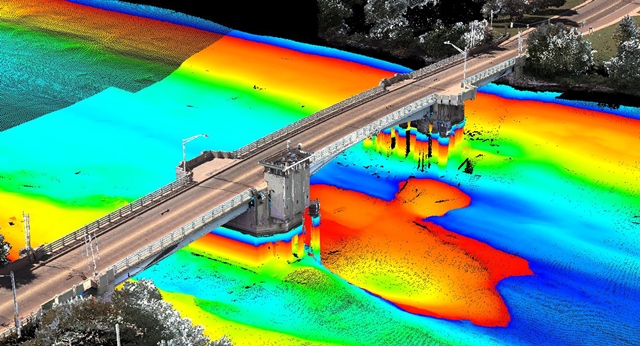
Bathymetric map
Topographic maps of the seafloor. Detailed depth contours provide the size, shape, and distribution of underwater features. The map serves as a tool for performing scientific, engineering, marine geophysical and environmental studies, that are required in the development of energy and marine resources. (Underwater Topography Maps)
Geological survey
Topo/Bathy Maps: Detailed multipurpose maps of NOS bathymetry and US Geological Survey (USGS) land topography. Maps support the Coastal Zone Management and Energy Impact Programs and the offshore oil and gas program.
They may also be used by land-use planners, conservationists, oceanographers, marine geologists, and those interested in the coastal zone and the Outer Continental Shelf’s (OCS) physical environment. All 1:250,000 and 1:1000,000 maps are overprinted with the Minerals Management Service’s OCS Protraction Diagram data. (Underwater Topography Maps)
Bathy fishing maps
Topographic maps of the seafloor produced at a 1:100,000 scale that contains Loran-C rates, bottom sediment types and known bottom obstructions. This product is intended to aid fishermen and those needing seafloor features and potential fishing grounds.
Geophysical mapping
Geophysical Maps: Each consist of three sheets (a base bathymetric map, a magnetic map, and a gravity map), and where practicable a sediment overprint (NOS 1308N-17S). The bathymetric map, when combined with the other three maps, serves as a base for making geological-geophysical studies of the oceans bottom’s crustal geophysical data for the Continental Shelf and slope. The SEAMAP SERIES at a scale of 1:1,000,000, covers geophysical data gathered in the deep-sea area, sometimes including the adjacent Continental Shelf and Slope. (Underwater Topography Maps)
PreliminaryBathymetric Maps
Bathymetric maps that have been compiled, but are not published. NOAA provides blackline copies of compilation manuscripts for bathymetric maps that were left in the production process but are sufficiently developed to include accurate bathymetric data. There are no plans to have these maps published.
Regional Maps
1:1,000,000 scale maps compiled from 1:250,000 scale bathymetric maps.
Underwater Topography Maps
Reading topographic maps
Underwater contours Maps: Interpreting the colored lines, areas, and other symbols are the first step in using topographic maps. Features are shown as points, lines, or areas, depending on their size and extent. For example, individual houses may be shown as small black squares. For larger buildings, the actual shapes are mapped. In densely built-up areas, most individual buildings are omitted and an area tint is shown. On some maps, post offices, churches, city halls, and other landmark buildings are shown within the tinted area.
The first features usually noticed on a topographic map are the area features, such as
vegetation (green)
water (blue), and
densely built-up areas (gray or red).
Many features are shown by lines that may be straight, curved, solid, dashed, dotted, or in any combination. The colors of the lines usually indicate similar classes of information:
topographic contours (brown);
lakes, streams, irrigation ditches, and other hydrographic features (blue);
land grids and important roads (red); and other
roads and trails, railroads, boundaries, and other cultural features (black).
Bathymetric contours are shown in blue or black, depending on their location. They show the shape and slope of the ocean bottom surface. The bathymetric contour interval may vary on each map and is explained in the map margin.
Underwater Topography Maps
Offshore exploration
Exploration in offshore is an important and costly affair for offshore exploration companies. The mighty ocean survey is not only expensive but also be consuming.
Remote sensing has opened up a new tool for offshore exploration. The ocean floor is characterized by the presence of numerous seamounts, atolls, ridges, trenches, etc.
The variation in relief constitutes the morphology of the ocean floor. Charting of the ocean is very important for many reasons: it affects circulation, a potential site for living and non-living resources, submarine navigation, geophysical exploration, etc.
Most areas of the oceans are uncharted because ships could map only a small fraction of the seafloor.
In brief bathymetry is the seafloor-relief.
Underwater Topography Maps
Undersea topography
Detailed bathymetry data of the seafloor in offshore is sparse as bathymetry data collection is expensive and me-consuming and complete coverage of the whole area by ship is a daunting task to be achieved in the years to come.
Hence, bathymetry prediction using high-resolution satellite gravity may be a viable op on in the unexplored regions. The most commonly used model to relate gravity with bathymetry is a convolution model. Bathymetry, when convolved with a response function, yields geoid or gravity.
The surface of the ocean is a good approximation to the marine geoid. A major contribution to the marine geoid is made by topographic anomalies in the very shallow rock water interface at the base of the ocean because this surface represents the large density contrast. The largest contrasts occur at the earth’s surface and at the ocean bottom (or at the base of the sediments in the ocean) and are affected by seafloor undulations. Consequently, there is a strong correlation between the shape of the geoid and ocean bottom topography.
Underwater Topography Maps
What is bathymetric data?
What is bathymetric data?
Bathymetry is the study of underwater depth of lake or ocean floors. In other words, bathymetry is the underwater equivalent to hypsometry or topography.
What kind of map shows water depth?
Bathymetry is the measurement of the depth of water in oceans, rivers, or lakes. Bathymetric maps look a lot like topographic maps, which use lines to show the shape and elevation of land features.
Why is bathymetry important?
The variation in relief constitutes the morphology of the ocean floor. Charting of the ocean is very important for many reasons: it affects circulation, a potential site for living and non-living resources, submarine navigation, geophysical exploration, etc. In brief, bathymetry is the seafloor-relief.
What is an underwater topography map?
Topographic maps of the seafloor. Detailed depth contours provide the size, shape, and distribution of underwater features. The map serves as a tool for performing scientific, engineering, marine geophysical and environmental studies, that are required in the development of energy and marine resources.
What are the basic types of maps?
According to the ICSM (Intergovernmental Committee on Surveying and Mapping), there are five different types of maps: General Reference, Topographical, Thematic, Navigation Charts and Cadastral Maps and Plans
While most people think of land surveys in the most basic sense, that is, the drawing of the boundaries of property, there are actually many different ways of surveying that service many different industries.
The variation in relief constitutes the morphology of the ocean floor. Charting of the ocean is very important for many reasons: it affects circulation, a potential site for living and non-living resources, submarine navigation, geophysical exploration, etc.